Scaricare la presentazione
La presentazione è in caricamento. Aspetta per favore

1
Geocaching Introduzione al COMENIUS project 06/07 Inverness (UK)
Mestre-Venezia (IT) Kerpen-Colonia (DE) Fuentesaúco-Salamanca (SP)
 Kerpen-Colonia (DE) Fuentesaúco-Salamanca (SP)")
2
La storia del GPS Global Positioning System (GPS) is a technology that uses the position of satellites to determine locations on earth. The U.S. Department of Defense decided that the military had to have a super precise form of worldwide positioning. And fortunately they had the kind of money ($12 billion!) it took to build something really good.
 is a technology that uses the position of satellites to determine locations on earth. The U.S. Department of Defense decided that the military had to have a super precise form of worldwide positioning. And fortunately they had the kind of money ($12 billion!) it took to build something really good.")
3
La storia del GPS The US previously employed a technique called Selective Availability (SA) to globally degrade the civilian GPS signal. New technologies demonstrated by the military enable the U.S. to degrade the GPS signal on a regional basis. GPS users world-wide would not be affected by regional, security-motivated, GPS degradations, and businesses reliant on GPS could continue to operate at peak efficiency.
 to globally degrade the civilian GPS signal. New technologies demonstrated by the military enable the U.S. to degrade the GPS signal on a regional basis. GPS users world-wide would not be affected by regional, security-motivated, GPS degradations, and businesses reliant on GPS could continue to operate at peak efficiency.")
4
What’s GPS? GPS is a system of 27 satellites (24 active, 3 reserve) to calculate a position. Satellites transmit their current position down to Earth via radio waves. GPS devices receive signals from GPS satellites and determine latitude and longitude of current position on the Earth's surface.

5
The GPS can guarantee that there are at least 4 (normally 8) of them above the horizon for any point on earth at any time. Each satellite contains an atomic clock. The satellites send radio signals to GPS receivers so that the receivers can find out how far away each satellite is (sometimes with millimetres precision) at a given time. That means we have to be outside in a fairly open area for the GPS receiver to work.
 at a given time. That means we have to be outside in a fairly open area for the GPS receiver to work.")
6
Funzionamento GPS (1) q Basato sul metodo della triangolazione q Da considerazioni geometriche si ricava che: q una distanza da un punto determina una superficie sferica q due misure determinano una circonferenza data dall’intersezione di due sfere q una terza misura individua su questa circonferenza 2 punti, uno dei quali può essere scartato in quanto interno alla terra oppure nello spazio che si muove ad altissima velocità q La distanza satellite-ricevitore può essere derivata conoscendo la posizione del satellite considerato e noto il tempo impiegato dal segnale del satellite per raggiungere il ricevitore GPS q Sfruttando questo principio, si può determinare la posizione di un punto sulla superficie terrestre dalla misura della distanza del punto rispetto a tre satelliti in orbita

7
Funzionamento GPS (2) In realtà sono 4 le incognite del sistema: q Latitudine q Longitudine q Quota q Tempo (l’orologio del satellite e quello del ricevitore non sono perfettamente sincronizzati) q Sono quindi necessari almeno 4 satelliti per localizzare un ricevitore GPS in uno spazio 3D q Una perfetta sincronizzazione tra gli orologi è fondamentale: un millesimo di secondo può penalizzare la localizzazione nell’ordine dei 300 km!!! q 3 Satelliti sono sufficienti nel caso in cui la quota sia nota (es. nella navigazione, altitudine = 0)
 q Sono quindi necessari almeno 4 satelliti per localizzare un ricevitore GPS in uno spazio 3D. q Una perfetta sincronizzazione tra gli orologi è fondamentale: un millesimo di secondo può penalizzare la localizzazione nell’ordine dei 300 km!!! q 3 Satelliti sono sufficienti nel caso in cui la quota sia nota (es. nella navigazione, altitudine = 0)")
8
Imprecisione nella Localizzazione (1)
Il segnale non viaggia nel vuoto. Attraversa: q Ionosfera (0-70 km) densa di particelle cariche elettricamente e quindi in grado di deviare le onde radio q Troposfera ( km) caratterizzata da una forte presenza di acqua Risultato: q rifrazioni e variazioni di velocità che producono allungamenti e deviazioni dei percorsi del segnale rispetto a quelli previsti rettilinei Importante notare che tali ritardi non sono costanti ma dipendono da: q elevazione del satellite: segnali dei satelliti di bassa elevazione sono maggiormente soggetti a variazioni (maggiore distanza percorsa attraverso la ionosfera). Tipicamente si impone una soglia (es. 15° di elevazione) q influenza dal sole: la densità della ionosfera subisce l’influenza del sole; in particolare, questa diminuisce durante la notte, mentre aumenta durante il giorno causando il rallentamento del segnale.
 densa di particelle cariche elettricamente e quindi in grado di deviare le onde radio. q Troposfera ( km) caratterizzata da una forte presenza di acqua. Risultato: q rifrazioni e variazioni di velocità che producono allungamenti e deviazioni dei percorsi del segnale rispetto a quelli previsti rettilinei. Importante notare che tali ritardi non sono costanti ma dipendono da: q elevazione del satellite: segnali dei satelliti di bassa elevazione sono maggiormente soggetti a variazioni (maggiore distanza percorsa attraverso la ionosfera). Tipicamente si impone una soglia (es. 15° di elevazione) q influenza dal sole: la densità della ionosfera subisce l’influenza del sole; in particolare, questa diminuisce durante la notte, mentre aumenta durante il giorno causando il rallentamento del segnale.")
9
Componenti GPS 3 componenti principali: q il segmento spaziale, formato dalla costellazione satellitare GPS orbitante intorno alla terra q il segmento di controllo, costituito da cinque stazioni GPS permanenti poste approssimativamente lungo l’equatore q il segmento utente, rappresentato dai dispositivi dotati di ricevitore GPS

10
Segmento Spaziale Composto da una costellazione di 24 satelliti (21 operativi e 3 di riserva) I satelliti sono disposti su 6 orbite: q spaziate tra loro di 60° gradi q inclinate di 55° rispetto al piano equatoriale q disposte su diverse quote (~ km da terra) q il periodo orbitale è di 12 ore siderali (corrispondenti a 11h 56m) q in qualsiasi momento ed in qualsiasi posizione sono visibili 4-12 satelliti Satellite: q ~7 anni di vita, 2T di peso e 5m di diametro q 4 orologi atomici: 2 al rubidio e 2 al cesio Ogni satellite trasmette a terra dati contenenti un segnale di tempo e informazioni sulle effemeridi orbitali (ovvero coordinate Xs(t), Ys(t) e Zs(t)) Utilizzando due onde portanti modulate in fase: q L MHz (10.23 x 154): destinato ad uso militare; q L MHz (10.23 x 120): destinato ad uso civile
 q il periodo orbitale è di 12 ore siderali (corrispondenti a 11h 56m) q in qualsiasi momento ed in qualsiasi posizione sono visibili 4-12 satelliti. Satellite: q ~7 anni di vita, 2T di peso e 5m di diametro. q 4 orologi atomici: 2 al rubidio e 2 al cesio. Ogni satellite trasmette a terra dati contenenti un segnale di tempo e informazioni sulle effemeridi orbitali (ovvero coordinate Xs(t), Ys(t) e Zs(t)) Utilizzando due onde portanti modulate in fase: q L MHz (10.23 x 154): destinato ad uso militare; q L MHz (10.23 x 120): destinato ad uso civile.")
11
Segmento di Controllo q Permette di controllare da terra i satelliti e le informazioni da questi trasmesse q 5 stazioni di tracking per il monitoraggio (uniformemente intervallate in longitudine), una stazione master (caratterizzata da sofisticate apparecchiature, es. orologio atomico all’idrogeno) Funzionalità: q traccia i satelliti GPS, ne aggiorna la posizione orbitale e provvede alla calibrazione e sincronizzazione degli orologi dei satelliti q determina l'orbita di ciascun satellite e la previsione del percorso per le seguenti 24 ore. Tale informazione viene trasmessa a ciascun satellite che la ritrasmette al segmento utente, consentendo quindi al ricevitore GPS di individuare la posizione di ciascun satellite.
, una stazione master (caratterizzata da sofisticate apparecchiature, es. orologio atomico all’idrogeno) Funzionalità: q traccia i satelliti GPS, ne aggiorna la posizione orbitale e provvede alla calibrazione e sincronizzazione degli orologi dei satelliti. q determina l orbita di ciascun satellite e la previsione del percorso per le seguenti 24 ore. Tale informazione viene trasmessa a ciascun satellite che la ritrasmette al segmento utente, consentendo quindi al ricevitore GPS di individuare la posizione di ciascun satellite.")
12
Segmento Utente q Rappresentato da qualunque apparecchiatura che utilizzi un ricevitore GPS

13
Migliorare l’Accuratezza nella Localizzazione: DGPS
q La correzione differenziale delle posizioni (DGPS) può eliminare parte degli errori che influiscono sull’accuratezza della localizzazione (precisione < 5m) q Sistemi WAAS (statunitense) ed EGNOS (europeo) sono utilizzabili per applicazioni civili. Si utilizzano contemporaneamente due strumenti riceventi: q una stazione fissa posta in una locazione di cui sono note le coordinate q un ricevitore mobile di cui si vuole conoscere la posizione La stazione base calcola l’errore tra la posizione misurata e quella nota ed archivia le correzioni e le loro variazioni nel tempo Tali correzioni vengono comunicate ai ricevitori che si trovano nelle vicinanze della base
 può eliminare parte degli errori che influiscono sull’accuratezza della localizzazione (precisione < 5m) q Sistemi WAAS (statunitense) ed EGNOS (europeo) sono utilizzabili per applicazioni civili. Si utilizzano contemporaneamente due strumenti riceventi: q una stazione fissa posta in una locazione di cui sono note le coordinate. q un ricevitore mobile di cui si vuole conoscere la posizione. La stazione base calcola l’errore tra la posizione misurata e quella nota ed archivia le correzioni e le loro variazioni nel tempo. Tali correzioni vengono comunicate ai ricevitori che si trovano nelle vicinanze della base.")
14
What’s Geocaching? The basic idea is to set up caches (hidden containers) and share the locations (latitude/longitude) of these caches on the internet. A cache is normally a weather-resistant container such as Tupperware or surplus ammo box
 and share the locations (latitude/longitude) of these caches on the internet. A cache is normally a weather-resistant container such as Tupperware or surplus ammo box.")
15
What’s Geocaching? GPS users can then use the coordinates to find the caches. The visitor may take something from the cache, leave something, and/or sign the logbook. The “find” is then logged onto the Internet website where statistics about found and hidden caches are maintained.

16
Geocaches are not allowed to be buried in the ground.
What’s Geocaching? Geocaching can be thought of in two parts: The journey to reach the cache area. The challenge of actually finding the cache container. Both can be equally rewarding. Geocaches are not allowed to be buried in the ground.

17
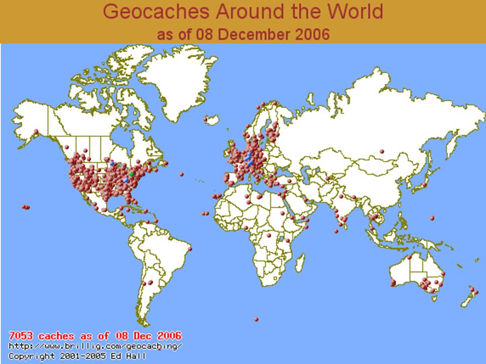
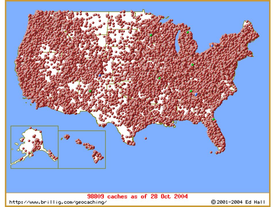
How did it get started? Jeremy Irish, the owner of the Geocaching.com website, expanded the idea and named it “Geocaching”. Geocaching is now in all 50 states and more than 200 countries. Geocaching.com is by far the #1 website for geocachers.

20
Inverness Colonia Venezia Salamanca

22
What’s in a cache? Logbook Trinkets to trade
Examples: maps, books, software, hardware, CDs, videos, pictures, coins, tools, games, etc. Information sheet that explains the container and geocaching, as well as contact information. Disposable camera (optional)
")
23
What are the rules? Cache placement (1)
No caches on land maintained by the National Park Service or Wildlife Service (National Wildlife Refuges) No caches that are buried. No caches placed on archaeological or historical sites. No caches close to active railroad tracks. 150 feet minimum.
 No caches that are buried. No caches placed on archaeological or historical sites. No caches close to active railroad tracks. 150 feet minimum.")
24
What are the rules? Cache placement (2)
No caches on military installations. No caches near or under highway bridges, dams, government buildings, or airports. No caches on school property without permission.

26
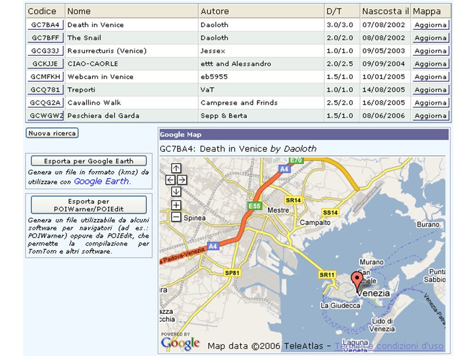
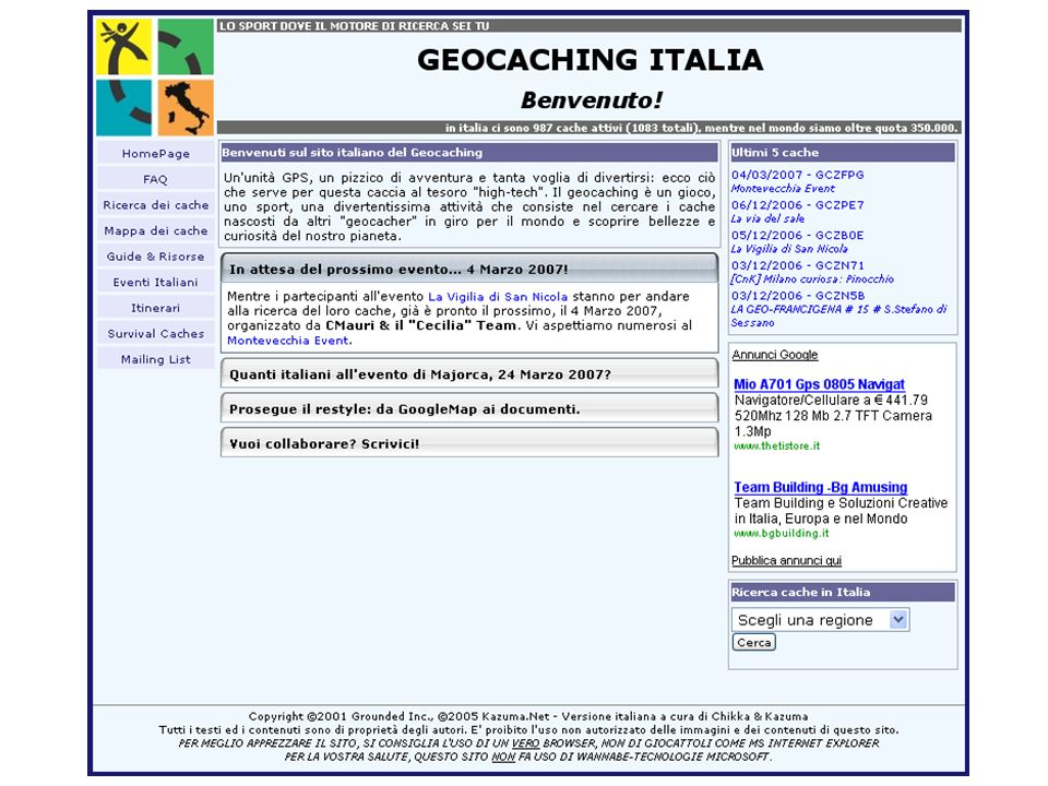
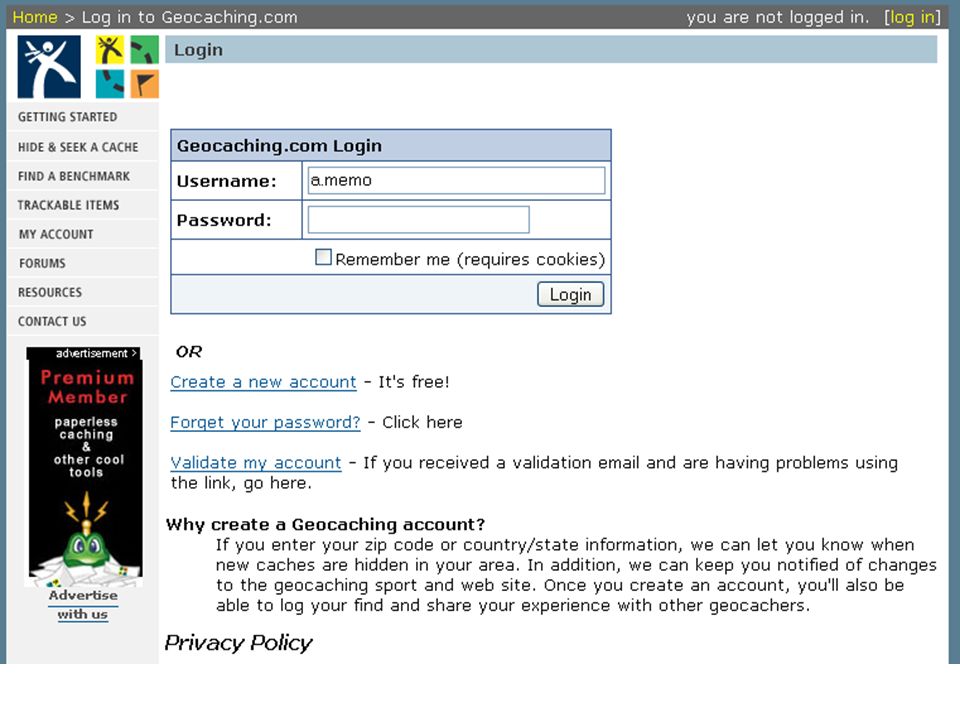
Geocaching.com Il sito di riferimento è: www.geocaching.com
altri link utili: it.wikipedia.org/wiki/Geocaching

28
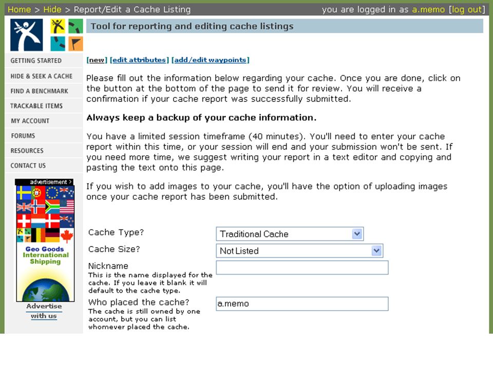
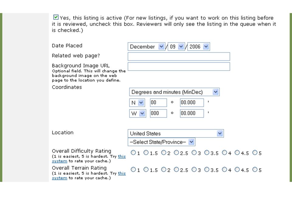
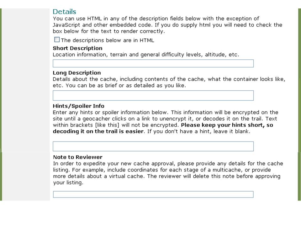
La tua prima ricerca Fase 1 – Identificare il cache

29
Geocaching F.A.Q. (Frequently Asked Questions)
What is this 'geocaching' thing anyway? What's a GPS receiver? What's the catch? What does one find in a typical cache? How much does geocaching cost? What should I NOT put in a cache? Who goes geocaching? What precautions should I take? Who invented geocaching?

35
What is Geocaching? In short, it is a high tech treasure hunt.
To find a “cache” use a handheld GPS receiver and coordinates found on geocaching websites. Enter the coordinates into the receiver and let the receiver guide you to the cache.

36
Variations in Geocaching
There are many variations in geocaching: Offset caches: The coordinates are usually a historical monument or plaque. From there you would look for offset numbers stamped or written nearby the location and/or continue based on instructions found. Multi-caches: The first cache gives coordinates to the next location or multiple caches give hints to the final cache.

37
Variations in Geocaching
Virtual cache: The cache is an existing landmark, such as a tombstone or statue. You have to answer a question from the landmark and let cache “owner” know as proof you were there.

38
What is a cache? A cache can be anything. Usually there is a logbook.
There are, many times, other things too, like geocoins, information about local landmarks, candy, stickers, etc. Caches can be found anywhere, from under a park bench to the side of a cliff. Usually are in a pretty conservative place.

39
Cost? The only thing you need to go geocaching is a GPS receiver and coordinates to the location. is a site that is free, you just have to be a member to get the coordinates, which are given in Latitude and Longitude and also UTM.

Presentazioni simili


>")


:>")


