Scaricare la presentazione
La presentazione è in caricamento. Aspetta per favore

1
Il Sistema Solare Interno I compagni di viaggio della nostra Terra
Stefano Covino INAF/Osservatorio Astronomico di Brera UTL Vimercate

2
Il Sole e Nove Pianeti… o Otto?
Il sistema solare! Il Sole e Nove Pianeti… o Otto? Mercurio Terra Giove Urano Plutone Il Sole Venere Marte Saturno Nettuno

3
Il Sole É (praticamente) il centro del nostro sistema.
99.85% della massa del sistema solare 74% H / 24% He / 2% Z Influenza l’ambiente con la gravità, la luce, I raggi cosmici, I campi magnetici, ecc. Studiato da missioni dedicate come la Missione Genesis e la SOHO SOHO Image Extreme Ultraviolet Imaging Telescope (EIT) image of a huge, handle-shaped prominence taken on Sept. 14,1999 taken in the 304 angstrom wavelength - Prominences are huge clouds of relatively cool dense plasma suspended in the Sun's hot, thin corona. At times, they can erupt, escaping the Sun's atmosphere. Emission in this spectral line shows the upper chromosphere at a temperature of about 60,000 degrees K. Every feature in the image traces magnetic field structure. The hottest areas appear almost white, while the darker red areas indicate cooler temperatures. More information on Sun at And at And at
 image of a huge, handle-shaped prominence taken on Sept. 14,1999 taken in the 304 angstrom wavelength - Prominences are huge clouds of relatively cool dense plasma suspended in the Sun s hot, thin corona. At times, they can erupt, escaping the Sun s atmosphere. Emission in this spectral line shows the upper chromosphere at a temperature of about 60,000 degrees K. Every feature in the image traces magnetic field structure. The hottest areas appear almost white, while the darker red areas indicate cooler temperatures. More information on Sun at And at And at")
4
I Pianeti Interni “Pianeti Terrestri” Rocciosi Densi

5
Mercurio Il più piccolo dei pianeti (0.4 la Terra)
Il più vicino al Sole, orbita in 88 giorni Alla superficie passiamo da a 427 ºC Forse ghiaccio ai poli. Nessuna atmosfera Il Mariner 3 lo ha sorvolato nel e nel 1975, il 40% della superficie è stato fotografato. Information about Mercury at And at

6
Mercurio Luna Original Caption Released with Image:
Antoniadi Ridge, over 450 kilometers long, runs along the right side of this image. The ridge transects a large crater (80-km in diameter) and in turn appears to be interrupted by an irregular rimless depression on the floor of the crater. This ridge also crosses smooth plains to the north and intercrater plains to the south of the large crater. This image (FDS 27325) was acquired during the spacecraft's first encounter with Mercury. The Mariner 10 mission, managed by the Jet Propulsion Laboratory for NASA's Office of Space Science, explored Venus in February 1974 on the way to three encounters with Mercury-in March and September 1974 and in March The spacecraft took more than 7,000 photos of Mercury, Venus, the Earth and the Moon. Image Credit: NASA/JPL/Northwestern University Luna
 and in turn appears to be interrupted by an irregular rimless depression on the floor of the crater. This ridge also crosses smooth plains to the north and intercrater plains to the south of the large crater. This image (FDS 27325) was acquired during the spacecraft s first encounter with Mercury. The Mariner 10 mission, managed by the Jet Propulsion Laboratory for NASA s Office of Space Science, explored Venus in February 1974 on the way to three encounters with Mercury-in March and September 1974 and in March The spacecraft took more than 7,000 photos of Mercury, Venus, the Earth and the Moon. Image Credit: NASA/JPL/Northwestern University. Luna.")
7
Faglie lungo la superficie…
Thrust faults: The radius of Mercury decreased by miles after the solidification and impact cratering of the surface. This was probably due to the cooling of the planet. Original Caption Released with Image: Intercrater plains and heavily cratered terrain typical of much of Mercury outside the area affected by the formation of the Caloris basin are shown in this image (FDS 27488) taken during the spacecraft's first encounter with Mercury. Abundant shallow elongate craters and crater chains are present on the intercrater plains. Large tract of intercrater plains centered at 3 degrees N, 20 degrees W. Prominent scarp Santa Maria Rupes cuts both intercrater plains and old craters. North is to the top of this image which is 200 kilometers across. The Mariner 10 mission, managed by the Jet Propulsion Laboratory for NASA's Office of Space Science, explored Venus in February 1974 on the way to three encounters with Mercury-in March and September 1974 and in March The spacecraft took more than 7,000 photos of Mercury, Venus, the Earth and the Moon. Image Credit: NASA/JPL/Northwestern University Faglie lungo la superficie…
 taken during the spacecraft s first encounter with Mercury. Abundant shallow elongate craters and crater chains are present on the intercrater plains. Large tract of intercrater plains centered at 3 degrees N, 20 degrees W. Prominent scarp Santa Maria Rupes cuts both intercrater plains and old craters. North is to the top of this image which is 200 kilometers across. The Mariner 10 mission, managed by the Jet Propulsion Laboratory for NASA s Office of Space Science, explored Venus in February 1974 on the way to three encounters with Mercury-in March and September 1974 and in March The spacecraft took more than 7,000 photos of Mercury, Venus, the Earth and the Moon. Image Credit: NASA/JPL/Northwestern University. Faglie lungo la superficie…")
8
L’interno di Mercurio Molto denso: 5.43 g/cm3
La superficie è di materiale simile a quello lunare. Dovrebbe avere un grande “core” di 75% di ferro e nickel Geologicamente inattivo da ~3.7 miliardi di anni Why so much iron? 1) heaviest stuff closest to sun – hot and refractory materials collected here; or 2) impact – blew off outer lighter layer of mantle. Mercury Cools As Mercury cooled it contracted. Its cold outer crust broke and slivers of crust thrust over each other, forming rough-edged ridges. Mercury's surface has been geologically inactive for about the last 3.7 billion years, other than occasional impacts. Mercury Mercury has an average density of 5430 kilograms per cubic meter, which is second only to Earth among all the planets. It is estimated that the planet Mercury, like Earth, has a ferrous core with a size equivalent to two-thirds to three-fourths that of the planet's overall radius. The core is believed to be composed of an iron-nickel alloy covered by a mantle and surface crust.
 heaviest stuff closest to sun – hot and refractory materials collected here; or 2) impact – blew off outer lighter layer of mantle. Mercury Cools. As Mercury cooled it contracted. Its cold outer crust broke and slivers of crust thrust over each other, forming rough-edged ridges. Mercury s surface has been geologically inactive for about the last 3.7 billion years, other than occasional impacts. Mercury Mercury has an average density of 5430 kilograms per cubic meter, which is second only to Earth among all the planets. It is estimated that the planet Mercury, like Earth, has a ferrous core with a size equivalent to two-thirds to three-fourths that of the planet s overall radius. The core is believed to be composed of an iron-nickel alloy covered by a mantle and surface crust.")
9
Dopo anni di “abbandono” la sonda Messenger ha segnato un rinnovato interesse verso Mercurio!

10
Venere Quasi la stessa dimensione della Terra (95%)
La più lenta rotazione fra tutti i pianeti (243 giorni) Per di più ha una rotazione retrograda La temperatura superficiale va da 377 a 487 C… più caldo di Mercurio Completamente coperto da nubi L’atmosfera, molto spessa, è composta prevalentemente da CO2 La pressione a terra è circa 100 volte quella terrestre E’ in atto un effetto serra molto intenso. P MGN-114 May 26, 1993 This global view of the surface of Venus is centered at 90 degrees east longitude. Magellan synthetic aperture radar mosaics from the three eight-month cycles of Magellan radar mapping are mapped onto a computer-simulated globe to create this image. Magellan obtained coverage of 98 percent of the surface of Venus. Remaining gaps are filled with data from previous Venus missions -- the Venera 15 and 16 radar and Pioneer-Venus Orbiter altimetry -- and data from Earth-based radar observations from the Arecibo radio telescope. Simulated color is used to enhance small-scale structures. The simulated hues are based on color images obtained by the Venera 13 and 14 landing craft. The bright feature near the center of the image is Ovda Regio, a mountainous region in the western portion of the great Aphrodite equatorial highland. The dark areas scattered across the Venusian plains consist of extremely smooth deposits associated with large meteorite impacts. The image was produced by the Solar System Visualization Project and the Magellan Science team at the Jet Propulsion Laboratory Multimission Image Processing Laboratory. The Magellan mission is managed by JPL for NASA's Office of Space Science. Lots of information about Venus at
 Per di più ha una rotazione retrograda. La temperatura superficiale va da 377 a 487 C… più caldo di Mercurio. Completamente coperto da nubi. L’atmosfera, molto spessa, è composta prevalentemente da CO2. La pressione a terra è circa 100 volte quella terrestre. E’ in atto un effetto serra molto intenso. P MGN-114 May 26, This global view of the surface of Venus is centered at 90 degrees east longitude. Magellan synthetic aperture radar mosaics from the three eight-month cycles of Magellan radar mapping are mapped onto a computer-simulated globe to create this image. Magellan obtained coverage of 98 percent of the surface of Venus. Remaining gaps are filled with data from previous Venus missions -- the Venera 15 and 16 radar and Pioneer-Venus Orbiter altimetry -- and data from Earth-based radar observations from the Arecibo radio telescope. Simulated color is used to enhance small-scale structures. The simulated hues are based on color images obtained by the Venera 13 and 14 landing craft. The bright feature near the center of the image is Ovda Regio, a mountainous region in the western portion of the great Aphrodite equatorial highland. The dark areas scattered across the Venusian plains consist of extremely smooth deposits associated with large meteorite impacts. The image was produced by the Solar System Visualization Project and the Magellan Science team at the Jet Propulsion Laboratory Multimission Image Processing Laboratory. The Magellan mission is managed by JPL for NASA s Office of Space Science. Lots of information about Venus at")
11
Immagini dai Venera (1982) Venus was visited by Mariner 2 in It has been visited by many others (more than 20 in all so far), including Pioneer Venus and the Soviet Venera 7 the first spacecraft to land on another planet, and Venera 9 which returned the first photographs of the surface. The first orbiter, the US spacecraft Magellan Magellan radar map (false color) produced detailed maps of Venus' surface using radar. ESA's Venus Express is now in orbit with a large variety of instruments. Sorvolato dal Mariner 2 nel 1962; 20 “visite” da allora, incluso gli atterraggi dei Venera e la mappatura del Magellan.
, including Pioneer Venus and the Soviet Venera 7 the first spacecraft to land on another planet, and Venera 9 which returned the first photographs of the surface. The first orbiter, the US spacecraft Magellan Magellan radar map (false color) produced detailed maps of Venus surface using radar. ESA s Venus Express is now in orbit with a large variety of instruments. Sorvolato dal Mariner 2 nel 1962; 20 visite da allora, incluso gli atterraggi dei Venera e la mappatura del Magellan.")
12
Sapas Mons – alto 1.5 km, largo 400 km (Atla Regio)
Gli altopiani vulcanici coprono l’85% della superficie di Venere con oltre 1100 vulcani identificati. Original Caption Released with Image: This false-color image shows the volcano Sapas Mons, which is located in the broad equatorial rise called Atla Regio (8 degrees north latitude and 188 degrees east longitude). The area shown is approximately 650 kilometers (404 miles) on a side. Sapas Mons measures about 400 kilometers (248 miles) across and 1.5 kilometers (0.9 mile) high. Its flanks show numerous overlapping lava flows. The dark flows on the lower right are thought to be smoother than the brighter ones near the central part of the volcano. Many of the flows appear to have been erupted along the flanks of the volcano rather than from the summit. This type of flank eruption is common on large volcanoes on Earth, such as the Hawaiian volcanoes. The summit area has two flat-topped mesas, whose smooth tops give a relatively dark appearance in the radar image. Also seen near the summit are groups of pits, some as large as one kilometer (0.6 mile) across. These are thought to have formed when underground chambers of magma were drained through other subsurface tubes and lead to a collapse at the surface. A 20 kilometer-diameter (12-mile diameter) impact crater northeast of the volcano is partially buried by the lava flows. Little was known about Atla Regio prior to Magellan. The new data, acquired in February 1991, show the region to be composed of at least five large volcanoes such as Sapas Mons, which are commonly linked by complex systems of fractures or rift zones. If comparable to similar features on Earth, Atla Regio probably formed when large volumes of molten rock upwelled from areas within the interior of Venus known as'hot spots.' Magellan is a NASA spacecraft mission to map the surface of Venus with imaging radar. The basic scientific instrument is a synthetic aperture radar, or SAR, which can look through the thick clouds perpetually shielding the surface of Venus. Magellan is in orbit around Venus which completes one turn around its axis in 243 Earth days. That period of time, one Venus day, is the length of a Magellan mapping cycle. The spacecraft completed its first mapping cycle and primary mission on May 15, 1991, and immediately began its second cycle. During the first cycle, Magellan mapped more than 80 percent of the planet's surface and the current and subsequent cycles of equal duration will provide complete mapping of Venus. Magellan was launched May 4, 1989, aboard the space shuttle Atlantis and went into orbit around Venus August 10, 1990. Image Note: C1-MIDR 09N188
. The area shown is approximately 650 kilometers (404 miles) on a side. Sapas Mons measures about 400 kilometers (248 miles) across and 1.5 kilometers (0.9 mile) high. Its flanks show numerous overlapping lava flows. The dark flows on the lower right are thought to be smoother than the brighter ones near the central part of the volcano. Many of the flows appear to have been erupted along the flanks of the volcano rather than from the summit. This type of flank eruption is common on large volcanoes on Earth, such as the Hawaiian volcanoes. The summit area has two flat-topped mesas, whose smooth tops give a relatively dark appearance in the radar image. Also seen near the summit are groups of pits, some as large as one kilometer (0.6 mile) across. These are thought to have formed when underground chambers of magma were drained through other subsurface tubes and lead to a collapse at the surface. A 20 kilometer-diameter (12-mile diameter) impact crater northeast of the volcano is partially buried by the lava flows. Little was known about Atla Regio prior to Magellan. The new data, acquired in February 1991, show the region to be composed of at least five large volcanoes such as Sapas Mons, which are commonly linked by complex systems of fractures or rift zones. If comparable to similar features on Earth, Atla Regio probably formed when large volumes of molten rock upwelled from areas within the interior of Venus known as hot spots. Magellan is a NASA spacecraft mission to map the surface of Venus with imaging radar. The basic scientific instrument is a synthetic aperture radar, or SAR, which can look through the thick clouds perpetually shielding the surface of Venus. Magellan is in orbit around Venus which completes one turn around its axis in 243 Earth days. That period of time, one Venus day, is the length of a Magellan mapping cycle. The spacecraft completed its first mapping cycle and primary mission on May 15, 1991, and immediately began its second cycle. During the first cycle, Magellan mapped more than 80 percent of the planet s surface and the current and subsequent cycles of equal duration will provide complete mapping of Venus. Magellan was launched May 4, 1989, aboard the space shuttle Atlantis and went into orbit around Venus August 10, Image Note: C1-MIDR 09N188.")
13
Monte Maat – alto 8 km Regione di Aphrodite Terra

14
Alpha Regio—Cupole “Pancake”
Pancake Domes This image shows a collection of volcanic features given the colorful nickname “pancake domes.” The steep sides of these features and their apparent emplacement in a single episode of volcanism has led to models of formation that seem to require a highly viscous, perhaps silicic, magma. These particular domes are located just southeast of Alpha Regio at 30°S, 12°E and can be seen in the slide of that region.

15
Pochi dati sull’interno. Densità simile alla Terra.
La superficie è vecchia millioni di anni Pochi crateri Basalti Nessun campo magnetico. Geologicamente attivo. Kinda flat… 60% of surface within 500 m of 0; 5% >2 km Highs and lows, but about 60% within 500 m of mean Volcanic flood plains cover 85% of surface 1100 volcanic centers identified Small shield volcanoes – circular outlines Intermediate constructs km flat topped steep sided thick lava – best evidence for silica lava Largest at 100 km and bigger – lava flows Basalts – flow look and venera camera shots – looks like basalt! Wrinkle ridges ( km long, 1 km wide – compressive Rifts (chasma) - extensional Isolated continental blocks – Ishtar with Maxwell Mons (Maxwell, chemist), the highest point at 12 km It is believed that the composition of the planet Venus is similar to that of Earth. The planet crust extends to around kilometers below the surface, under which the mantle reaches to a depth of some 3000 kilometers. The planet core comprises a liquid iron-nickel alloy. Average planet density is 5240 kilograms per cubic meter.
 - extensional. Isolated continental blocks – Ishtar with Maxwell Mons (Maxwell, chemist), the highest point at 12 km. It is believed that the composition of the planet Venus is similar to that of Earth. The planet crust extends to around kilometers below the surface, under which the mantle reaches to a depth of some 3000 kilometers. The planet core comprises a liquid iron-nickel alloy. Average planet density is 5240 kilograms per cubic meter.")
16
Terra Diametro 12756 km Asse di rotazione inclinato di 23 gradi
Temperatura alla supetficie da –73 a +48 C Atmosfera spessa. Moderato effetto serra. Acqua liquida! Information and statistics at

17
Geologicamente attiva
The Earth comprises three separate layers: a crust, a mantle, and a core (in descending order from the surface). The crust thickness averages 30 kilometers for land masses and 5 kilometers for seabeds. The mantle extends from just below the crust to some 2900 kilometers deep. The core below the mantle begins at a depth of around 5100 kilometers, and comprises an outer core (liquid iron-nickel alloy) and inner core (solid iron-nickel alloy). The crust is composed mainly of granite in the case of land masses and basalt in the case of seabeds. The mantle is composed primarily of peridotite and high-pressure minerals. Average planet density is 5520 kilograms per cubic meter.
. The crust thickness averages 30 kilometers for land masses and 5 kilometers for seabeds. The mantle extends from just below the crust to some 2900 kilometers deep. The core below the mantle begins at a depth of around 5100 kilometers, and comprises an outer core (liquid iron-nickel alloy) and inner core (solid iron-nickel alloy). The crust is composed mainly of granite in the case of land masses and basalt in the case of seabeds. The mantle is composed primarily of peridotite and high-pressure minerals. Average planet density is 5520 kilograms per cubic meter.")
18
Marte Diametro 6794 km, circa ½ della Terra
Asse di rotazione inclinato di 25 gradi Rotazione di circa ~24 ore e periodo orbitale di 687 giorni Piuttosto freddo. Da -83 a -33 C. Atmosfera sottile, 95% CO2, 3% N Acqua ghiacciata sotto la superficie? Information at Image caption: Global Mosaic of Mars Centered on Valles Marineris Date: Global mosaic of 102 Viking 1 Orbiter images of Mars taken on orbit 1,334, 22 February The images are projected into point perspective, representing what a viewer would see from a spacecraft at an altitude of 2,500 km. At center is Valles Marineris, over 3000 km long and up to 8 km deep. Note the channels running up (north) from the central and eastern portions of Valles Marineris to the dark area, Acidalic Planitia, at upper right. At left are the three Tharsis volcanoes and to the south is ancient, heavily impacted terrain. (Viking 1 Orbiter, MG07S SP) Image Credit: NASA
 from the central and eastern portions of Valles Marineris to the dark area, Acidalic Planitia, at upper right. At left are the three Tharsis volcanoes and to the south is ancient, heavily impacted terrain. (Viking 1 Orbiter, MG07S SP) Image Credit: NASA.")
19
Marte Gravità superficiale: 38% della Terra, circa come Mercurio
Vulcanismo Nessun campo magnetico Mars Mars is roughly one-half the diameter of Earth. Due to its small size, it is believed that the martian center has cooled. Geological structure is mainly rock and metal. The mantle below the crust comprises iron-oxide-rich silicate. The core is made up of an iron-nickel alloy and iron sulfide. Average planet density is 3930 kilograms per cubic meter.

20
Alcune delle montagne più imponenti del sistema solare sono su Marte!
The MOLA laser altimeter produced detailed topographic maps and profiles of Mars, and really revolutionized our understanding of Mars. So much from elevation alone! These maps show the MOLA altitude data coded into colors - blue is low and red/white are high. The basins and volcanos show very clearly Il Monte Olimpo Alcune delle montagne più imponenti del sistema solare sono su Marte!

21
Bordo Ovest della Regione di Tharsis
The volcanoes of the Tharsis region are highlighted by this color image mosaic obtained on a single martian afternoon by the Mars Orbiter Camera (MOC)onboard the Mars Global Surveyor (MGS) spacecraft. Olympus Mons dominates the upper left corner--it is one of the largest known volcanoes and is nearly 550 km (340 miles) wide. The grayscale image on the right shows the name of each volcano in the scene. The white or bluish-white features are clouds. Clouds are common over the larger Tharsis volcanoes in mid-afternoon. The four largest volcanoes are more than 15 km (9 mi) high. Viewed from Earth by telescope before any spacecraft had visited the planet, astronomers often described a "W"-shaped white cloud over the Tharsis region. This "W" was actually the result of seeing the combined effects of bright clouds hanging over the Ascraeus, Pavonis, Arsia, and Olympus volcanoes. The clouds result when warm air containing water vapor rises up the slopes of each volcano, cools at the higher altitude, and causes the water vapor to freeze and form a cloud of ice crystals. Pavonis Mons lies on the martian equator, north is up, and sunlight is illuminating the scene from the left. The picture is a mosaic of red and blue filter images taken on three consecutive orbits. The slightly blurred appearance of the left side of Arsia Mons results from distortion toward the edges of the images used to make the mosaic. To remove the blur, an image obtained on another day would be added to the mosaic--however, this image would not match well because the cloud patterns will have changed by the next day. Mosaics such as the one shown here are used to monitor changes in martian weather and to plan future observations. Image Credit: NASA/JPL/MSSS Centro della Regione di Tharsis
onboard the Mars Global Surveyor (MGS) spacecraft. Olympus Mons dominates the upper left corner--it is one of the largest known volcanoes and is nearly 550 km (340 miles) wide. The grayscale image on the right shows the name of each volcano in the scene. The white or bluish-white features are clouds. Clouds are common over the larger Tharsis volcanoes in mid-afternoon. The four largest volcanoes are more than 15 km (9 mi) high. Viewed from Earth by telescope before any spacecraft had visited the planet, astronomers often described a W -shaped white cloud over the Tharsis region. This W was actually the result of seeing the combined effects of bright clouds hanging over the Ascraeus, Pavonis, Arsia, and Olympus volcanoes. The clouds result when warm air containing water vapor rises up the slopes of each volcano, cools at the higher altitude, and causes the water vapor to freeze and form a cloud of ice crystals. Pavonis Mons lies on the martian equator, north is up, and sunlight is illuminating the scene from the left. The picture is a mosaic of red and blue filter images taken on three consecutive orbits. The slightly blurred appearance of the left side of Arsia Mons results from distortion toward the edges of the images used to make the mosaic. To remove the blur, an image obtained on another day would be added to the mosaic--however, this image would not match well because the cloud patterns will have changed by the next day. Mosaics such as the one shown here are used to monitor changes in martian weather and to plan future observations. Image Credit: NASA/JPL/MSSS. Centro della Regione di Tharsis.")
22
Dune e tempeste di sabbia
Sand Dunes in Kaiser Crater This Mars Global Surveyor (MGS) Mars Orbiter Camera (MOC) high resolution image shows a field of dark sand dunes on the floor of Kaiser Crater in southeastern Noachis Terra. The steepest slopes on each dune, the slip faces, point toward the east, indicating that the strongest winds that blow across the floor of Kaiser move sand in this direction. Wind features of three different scales are visible in this image: the largest (the dunes) are moving across a hard surface (light tone) that is itself partially covered by large ripples. These large ripples appear not to be moving--the dunes are burying some and revealing others. Another type of ripple pattern is seen on the margins of the dunes and where dunes coalesce. They are smaller (both in their height and in their separation) than the large ripples. These are probably coarse sediments that are moving with the dunes. This picture covers an area approximately 3 km (1.9 mi) across and is illuminated from the upper left. Photo Credit: NASA/JPL/Malin Space Science Systems Wind Streaks: This Mars Global Surveyor (MGS) Mars Orbiter Camera (MOC) picture shows dark wind streaks on a plain east of Olympus Mons in the Tharsis region of Mars. Streaks such as these change from time to time over the course of a martian year, suggesting that they are the result of wind movement of a thin layer of bright dust. In other words, wind is not moving dark material to make the dark streaks, it is removing bright material (thin coatings of dust). This picture is located near 16.3°N, 127.7°W. The image covers an area 3 km (1.9 mi) across and is illuminated by sunlight from the upper left.
 Mars Orbiter Camera (MOC) high resolution image shows a field of dark sand dunes on the floor of Kaiser Crater in southeastern Noachis Terra. The steepest slopes on each dune, the slip faces, point toward the east, indicating that the strongest winds that blow across the floor of Kaiser move sand in this direction. Wind features of three different scales are visible in this image: the largest (the dunes) are moving across a hard surface (light tone) that is itself partially covered by large ripples. These large ripples appear not to be moving--the dunes are burying some and revealing others. Another type of ripple pattern is seen on the margins of the dunes and where dunes coalesce. They are smaller (both in their height and in their separation) than the large ripples. These are probably coarse sediments that are moving with the dunes. This picture covers an area approximately 3 km (1.9 mi) across and is illuminated from the upper left. Photo Credit: NASA/JPL/Malin Space Science Systems. Wind Streaks: This Mars Global Surveyor (MGS) Mars Orbiter Camera (MOC) picture shows dark wind streaks on a plain east of Olympus Mons in the Tharsis region of Mars. Streaks such as these change from time to time over the course of a martian year, suggesting that they are the result of wind movement of a thin layer of bright dust. In other words, wind is not moving dark material to make the dark streaks, it is removing bright material (thin coatings of dust). This picture is located near 16.3°N, 127.7°W. The image covers an area 3 km (1.9 mi) across and is illuminated by sunlight from the upper left.")
23
Ghiaccio e polveri Anche ghiaccio di CO2
Water ice and dust in cap; winter CO2 layer forms, sublimates in spring Dark band = dune fields Color Image of Frost at Utopia Planitia on Mars This color image shows a thin layer of water ice frost on the martian surface at Utopia Planitia. It was taken by Viking 2 Lander camera 2 on 18 May 1979, almost exactly one martian year (687 days) after frost first appeared at this spot and was imaged by Viking 2. The layer is thought to be only a couple thousandths of a centimeter thick. It is speculated that dust particles in the atmosphere pick up tiny bits of water. When it gets cold enough for carbon dioxide to solidify, some of it attaches to the dust and ice and it falls to the surface. The view is looking towards the south southeast, the long boulder to the right is roughly one meter across. (Viking 2 Lander, P-21873 South Polar Cap This is the south polar cap of Mars as it appeared to the Mars Global Surveyor (MGS) Mars Orbiter Camera (MOC) on April 17, In winter and early spring, this entire scene would be covered by frost. In summer, the cap shrinks to its minimum size, as shown here. Even though it is summer, observations made by the Viking orbiters in the 1970s showed that the south polar cap remains cold enough that the polar frost (seen here as white) consists of carbon dioxide. Carbon dioxide freezes at temperatures around -125° C (-193° F). Mid-summer afternoon sunlight illuminates this scene from the upper left from about 11.2° above the horizon. Soon the cap will experience sunsets; by June 2000, this pole will be in autumn, and the area covered by frost will begin to grow. Winter will return to the south polar region in December The polar cap from left to right is about 420 km (260 mi) across. Photo Credit: NASA/JPL/Malin Space Science Systems Original Caption Released with Image: The north polar cap is visible in this projection at the top of the image, the great equatorial canyon system (Valles Marineris) below center, and four huge Tharsis volcanoes (and several smaller ones) at left. Also note heavy impact cratering of the highlands (bottom and right portions of this mosaic) and the younger, less heavily cratered terrains elsewhere. North polar cap is probably water-ice South polar cap is primarily frozen carbon dioxide Ghiaccio e polveri Anche ghiaccio di CO2 Si vedono le calotte ghiacciate espandersi e contrarsi a seconda delle stagioni.
 after frost first appeared at this spot and was imaged by Viking 2. The layer is thought to be only a couple thousandths of a centimeter thick. It is speculated that dust particles in the atmosphere pick up tiny bits of water. When it gets cold enough for carbon dioxide to solidify, some of it attaches to the dust and ice and it falls to the surface. The view is looking towards the south southeast, the long boulder to the right is roughly one meter across. (Viking 2 Lander, P South Polar Cap This is the south polar cap of Mars as it appeared to the Mars Global Surveyor (MGS) Mars Orbiter Camera (MOC) on April 17, In winter and early spring, this entire scene would be covered by frost. In summer, the cap shrinks to its minimum size, as shown here. Even though it is summer, observations made by the Viking orbiters in the 1970s showed that the south polar cap remains cold enough that the polar frost (seen here as white) consists of carbon dioxide. Carbon dioxide freezes at temperatures around -125° C (-193° F). Mid-summer afternoon sunlight illuminates this scene from the upper left from about 11.2° above the horizon. Soon the cap will experience sunsets; by June 2000, this pole will be in autumn, and the area covered by frost will begin to grow. Winter will return to the south polar region in December The polar cap from left to right is about 420 km (260 mi) across. Photo Credit: NASA/JPL/Malin Space Science Systems. Original Caption Released with Image: The north polar cap is visible in this projection at the top of the image, the great equatorial canyon system (Valles Marineris) below center, and four huge Tharsis volcanoes (and several smaller ones) at left. Also note heavy impact cratering of the highlands (bottom and right portions of this mosaic) and the younger, less heavily cratered terrains elsewhere. North polar cap is probably water-ice. South polar cap is primarily frozen carbon dioxide. Ghiaccio e polveri. Anche ghiaccio di CO2. Si vedono le calotte ghiacciate espandersi e contrarsi a seconda delle stagioni.")
24
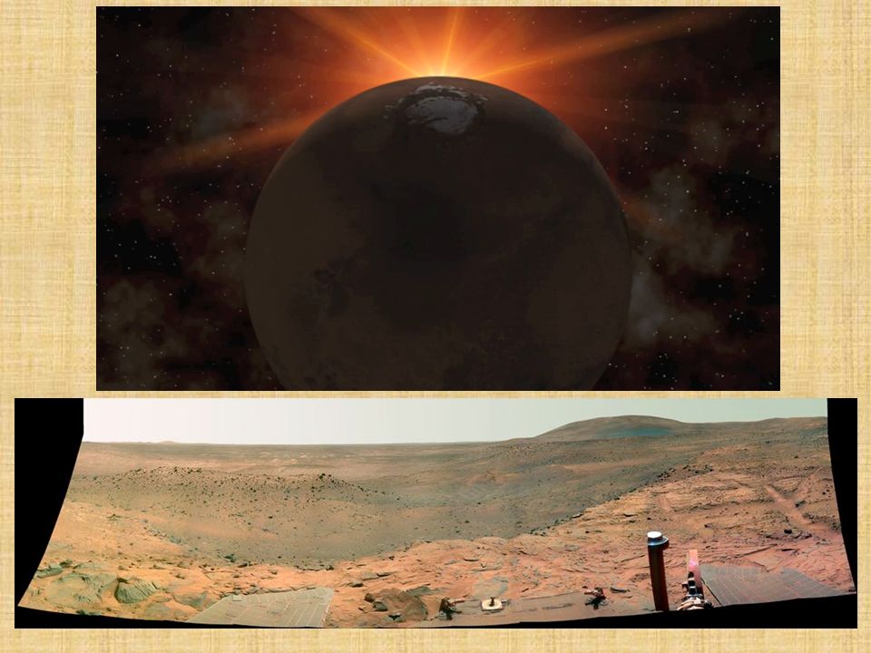
Acqua su Marte? Cratere Gale (170km)
")
25
Marte Atterriamo su Marte!

27
Ida Asteroidi “Pianeti minori” o “planetoidi” con dimensioni inferiori a 1000 km La fascia degli asteroidi è fra Marte e Giove. Ida This view of the asteroid 243 Ida was acquired by the Galileo spacecraft at ranges of 3,057 to 3,821 kilometers (1,900 to 2,375 miles) on August 28, 1993, about 3.5 minutes before the spacecraft made its close approach to the asteroid. This view shows numerous craters, including many degraded craters larger than any seen on Gaspra. The south pole is believed to be in the dark side near the middle of the asteroid. (Courtesy NASA/JPL) More information on asteroids at: And at
 on August 28, 1993, about 3.5 minutes before the spacecraft made its close approach to the asteroid. This view shows numerous craters, including many degraded craters larger than any seen on Gaspra. The south pole is believed to be in the dark side near the middle of the asteroid. (Courtesy NASA/JPL) More information on asteroids at: And at")
28
La fascia di Kuiper Un disco di residui al bordo del Sistema Solare.
Plutone è un oggetto della fascia. Da qui provengono molte comete a corto periodo. Image from Information from The Nine Planets:

29
La Nube di Oort Sfera di oggetti da cui provengono le comete.
30 miliardi di km dal Sole Information on Sedna at This object is the most distant body known that orbits our Sun. It is at present over 90 AUs away, 3 times as far as Pluto. Sedna is about 1800 km in diameter, slightly smaller than Pluto.

Presentazioni simili


 2. nove pianeti 3. diverse.>")


