Scaricare la presentazione
La presentazione è in caricamento. Aspetta per favore

1
Politecnico e Università degli Studi di Torino
Dipartimento Interateneo Territorio I sistemi informativi territoriali: dalla mappa al bit. Una introduzione per “immagini” Antonio Cittadino, Francesco Fiermonte e Paola Guerreschi Parte II

2
PARTE SECONDA

3
Il software

4
GIS Software Packages Software proprietario, Libero & semi-libero

6
Fundamental GIS Operations
Capture Store Edit Analysis Display Output Capturing Data Databases GPS Remote Sensing Digitizing Existing Coverages Scanning Others Scegliere il Software in funzione dei propri obiettivi e/o delle proprie necessità

7
(Commercial) GIS Software Packages
ESRI, Inc., Redlands, CA clear market leader with about a third of the market originated commercial GIS with their ArcInfo product in 1981 privately owned by Jack Dangermond, a legend in the field Strong in gov., education, utilities and business logistics MapInfo, Troy N.Y. Aggressive newcomer in early 1990s, but now well-established. Strong presence in business, especially site selection & marketing, and telecom Intergraph, Huntsville, AL origins in proprietary CAD hardware/software Older UNIX-based MGE (Modular GIS Environment) evolved from CAD Current GeoMedia was the first true MS Windows-based GIS strong in design, public works, and FM (facilities management), but weakening Bentley Systems, Exton, PA MicroStation GeoGraphics, originally developed with Intergraph, is now their exclusive and main product.. Strong in engineering; advertises itself as “geoengineering” Autodesk, San Rafael, CA Began as PC-based CAD, but now the dominant CAD supplier First GIS product AutoCAD Map introduced in 1996 Primarily small business/small city customer base
 evolved from CAD. Current GeoMedia was the first true MS Windows-based GIS. strong in design, public works, and FM (facilities management), but weakening. Bentley Systems, Exton, PA. MicroStation GeoGraphics, originally developed with Intergraph, is now their exclusive and main product.. Strong in engineering; advertises itself as geoengineering Autodesk, San Rafael, CA. Began as PC-based CAD, but now the dominant CAD supplier. First GIS product AutoCAD Map introduced in Primarily small business/small city customer base.")
8
Software for GIS: other players
Vector GIS Smallworld Systems (Englewood, CO) first to use OO (early ‘90s), but failed to compete as established vendors did same Purchased by GE in 2000 emphasis on FM & utilities Manifold (CDA International Corp): low cost, but low market share Maptitude (Caliper Corp, Newton, MA): another low cost one Raster GIS ERDAS/Imagine long established leader acquired by Leica Geosystems in 2001 ER MAPPER aggressive newcomer originating in Australia Envi, relative newcomer, radar specialization acquired by Kodak in 2000 PCI--Geomatica long-term Canadian player CARIS newer Canadian entry GRASS (Rutgers Univ.) Classic old-timer originally developed by US Army Construction Engineering Research Lab(CERL) in Champaign, IL; army ended dev. & support in 1996 but assumed by Baylor University. IDRSI (Clark Univ) pioneering, university-developed package
 first to use OO (early ‘90s), but failed to compete as established vendors did same. Purchased by GE in emphasis on FM & utilities. Manifold (CDA International Corp): low cost, but low market share. Maptitude (Caliper Corp, Newton, MA): another low cost one. Raster GIS. ERDAS/Imagine. long established leader. acquired by Leica Geosystems in ER MAPPER. aggressive newcomer originating in Australia. Envi, relative newcomer, radar specialization. acquired by Kodak in PCI--Geomatica. long-term Canadian player. CARIS. newer Canadian entry. GRASS (Rutgers Univ.) Classic old-timer originally developed by US Army Construction Engineering Research Lab(CERL) in Champaign, IL; army ended dev. & support in 1996 but assumed by Baylor University. IDRSI (Clark Univ) pioneering, university-developed package.")
9
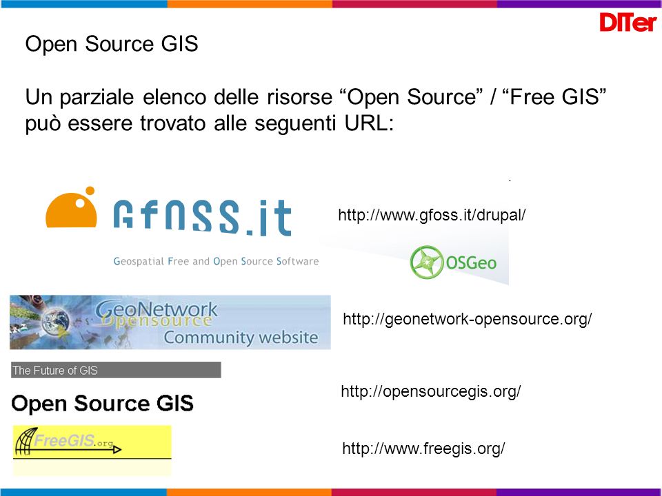
Open Source GIS Un parziale elenco delle risorse “Open Source” / “Free GIS” può essere trovato alle seguenti URL:
10
GRASS Official Page "GRASS GIs (Geographic Resources Analysis Support System) is an Open Source Geographical Information System (GIs) with raster, topological vector, image processing, and graphics production functionality that operates on various platforms through a graphical user interface and shell in X-Windows." gvSIG "gvSIG is a tool for handling geographical information. It has a friendly interface, and can access several (raster and vector) formats. It will integrate in a single view both local and remote data through WMS or WFS (WMS now working). HidroSIG "HidroSIG is a Geographical Information System (GIS) written in Java with special tools that will allow you to make estimations and analysis of hydrological, climatic and geomorphological variables." [ License: GNU Lesser General Public License (LGPL) ] JUMP "The Java Unified Mapping Platform (JUMP) is a GUI-based application for viewing and processing spatial data. It includes many common spatial and GIS functions. Kosmo "Kosmo has been implemented using the Java programming language and is being developed based on the JUMP platform and a long series of acknowledged free code libraries, such as Geotools and JTS, used in numerous free software projects. MapServer "MapServer is an OpenSource development environment for building spatially enabled Internet applications. The software builds upon other popular OpenSource or freeware systems like Shapelib, FreeType, Proj.4, libTIFF, Perl and others. Quantum GIS "Quantum GIS (QGIS) is a Geographic Information System (GIS) that runs on Linux, Unix, Mac OSX, and Windows. QGIS supports vector, raster, and database formats." [ License: GNU General Public License (GPL) ] QSlim "This package contains two components, the MixKit library and the SlimKit collection of surface modeling tools." [License: ? ] SAGA "You can understand SAGA as a geographic information system, with a special 'Application Programming Interface' (API) for geographic data processing. This API makes it easy to implement new algorithms and exempts the developer from hassle programming overhead like user-interface design or file-io. The SAGA API supports grid data like digital terrain models and satellite images, vector data, and tables." [ License: GNU General Public License (GPL) ]
 formats. It will integrate in a single view both local and remote data through WMS or WFS (WMS now working). HidroSIG HidroSIG is a Geographical Information System (GIS) written in Java with special tools that will allow you to make estimations and analysis of hydrological, climatic and geomorphological variables. [ License: GNU Lesser General Public License (LGPL) ] JUMP The Java Unified Mapping Platform (JUMP) is a GUI-based application for viewing and processing spatial data. It includes many common spatial and GIS functions. Kosmo Kosmo has been implemented using the Java programming language and is being developed based on the JUMP platform and a long series of acknowledged free code libraries, such as Geotools and JTS, used in numerous free software projects. MapServer MapServer is an OpenSource development environment for building spatially enabled Internet applications. The software builds upon other popular OpenSource or freeware systems like Shapelib, FreeType, Proj.4, libTIFF, Perl and others. Quantum GIS Quantum GIS (QGIS) is a Geographic Information System (GIS) that runs on Linux, Unix, Mac OSX, and Windows. QGIS supports vector, raster, and database formats. [ License: GNU General Public License (GPL) ] QSlim This package contains two components, the MixKit library and the SlimKit collection of surface modeling tools. [License: ] SAGA You can understand SAGA as a geographic information system, with a special Application Programming Interface (API) for geographic data processing. This API makes it easy to implement new algorithms and exempts the developer from hassle programming overhead like user-interface design or file-io. The SAGA API supports grid data like digital terrain models and satellite images, vector data, and tables. [ License: GNU General Public License (GPL) ]")
11
Il software ESRI

12
ESRI

13
ESRI Arc/Info Versions 1-7 from 1980 – 1999 Command-line driven Vector model: Coverages Raster analysis module called GRID Own raster model: GRID Released on Unix and Windows platforms Scripting done in Arc Macro Language (AML)
")
14
ESRI ArcView 3.x Versions 1-3 from 1994 – 1999 Graphical User Interface (GUI) Vector model: Shapefiles Raster analysis through extension called “Spatial Analyst” GRID model

15
ESRI ArcGIS Several hundred person-years invested Complete rewrite, first since 1980 Released in 2000 Arc/Info Workstation version 7 included ArcGIS Desktop on Windows ArcView as a subset ArcGIS 9.0 in 2005 Object-oriented programming Version 9.3 just released

16
Il software ArcGIS

17
Levels of ArcGIS Products
ArcView – View data and edit shape files and simple personal geodatabases ArcEditor – do more complex edits on enterprise geodatabases ArcInfo – the full system, with access to workstation ArcInfo (i.e. ArcInfo version 7) as well ArcGIS offre funzionalità diverse a seconda della licenza che si acquista…
 as well. ArcGIS offre funzionalità diverse a seconda della licenza che si acquista…")
18
ESRI Product Line-up: ArcGIS client products (Fall 2007)
ArcReader (“adobe acrobat” for maps) & ArcExplorer (spatial data viewer) Free viewers for geographic data. ArcGIS 9.x Desktop: two primary modules (MS only) ArcMap: for data display, map production, spatial analysis, data editing ArcCatalog: for data management and preview ArcToolbox, for specialized data conversions and analyses, available as a window in both Available capabilities within these modules are “tiered” in three levels ArcView: viewing, map production, spatial analysis, basic editing: ArcEditor: ArcView, plus specialized editing: ArcInfo: ArcView & ArcEditor plus special analyses and conversions: Extensions: for special apps.: Spatial Analyst, 3D Analyst, Geostatistics, Business Analyst, etc. ArcObjects: to build specialized capabilities within ArcMap or ArcCatalog using VB for Applications ArcGIS Workstation (for UNIX and MS) the old command line ArcInfo 7.1 ArcGIS Engine (MS NT/2000/XP) Set of embeddable GIS components (ArcObjects software objects) for use in building custom applications Runs under Windows, Unix and Linux, with support for Java, C++, COM and .NET Replaces MapObjects which were based upon a previous generation of GIS objects Notes: ArcView 3.3 the only GUI option for UNIX. ArcGIS 8 released 2000 to integrate two previous standalone products: ArcView and ArcInfo ArcGIS 9 released 2004 providing the full capability that should have been in ArcGIS 8!!! --full support for all data types (coverages, shapefiles, geodatabases) --full support for all previous geoprocessing analyses --Modelbuilder for scripting and repetitive processing --ArcEngine for building custom applications
 & ArcExplorer (spatial data viewer) Free viewers for geographic data. ArcGIS 9.x Desktop: two primary modules (MS only) ArcMap: for data display, map production, spatial analysis, data editing. ArcCatalog: for data management and preview. ArcToolbox, for specialized data conversions and analyses, available as a window in both. Available capabilities within these modules are tiered in three levels. ArcView: viewing, map production, spatial analysis, basic editing: ArcEditor: ArcView, plus specialized editing: ArcInfo: ArcView & ArcEditor plus special analyses and conversions: Extensions: for special apps.: Spatial Analyst, 3D Analyst, Geostatistics, Business Analyst, etc. ArcObjects: to build specialized capabilities within ArcMap or ArcCatalog using VB for Applications. ArcGIS Workstation (for UNIX and MS) the old command line ArcInfo 7.1. ArcGIS Engine (MS NT/2000/XP) Set of embeddable GIS components (ArcObjects software objects) for use in building custom applications. Runs under Windows, Unix and Linux, with support for Java, C++, COM and .NET. Replaces MapObjects which were based upon a previous generation of GIS objects. Notes: ArcView 3.3 the only GUI option for UNIX. ArcGIS 8 released 2000 to integrate two previous standalone products: ArcView and ArcInfo. ArcGIS 9 released 2004 providing the full capability that should have been in ArcGIS 8!!! --full support for all data types (coverages, shapefiles, geodatabases) --full support for all previous geoprocessing analyses. --Modelbuilder for scripting and repetitive processing. --ArcEngine for building custom applications.")
19
Database storage/access
ESRI ArcGIS System Clients Consistent interface Increasing capability c:\ ArcGIS Workstation ArcInfo ArcEditor ArcView $ ArcExplorer Browser ArcMap ArcCatalog ArcToolbox ArcMap ArcCatalog ArcToolbox ArcMap ArcCatalog ArcToolbox ArcServer Services Full GIS analysis ArcEngine/ ArcObjects Application Development & Customization ArcIMS Services Map display & query ArcSDE Services Database storage/access Internet Source: ESRI with mods.

20
Future Generic GIS Internet Enterprise
Browsers Applications Web Web Server Broker Services ( built on .Net, SOAP/XML, Java API) Dallas Delhi Durban Source: Reza Wahadj, CSIG04, with mods. Databases
 Dallas. Delhi. Durban. Source: Reza Wahadj, CSIG04, with mods. Databases.")
21
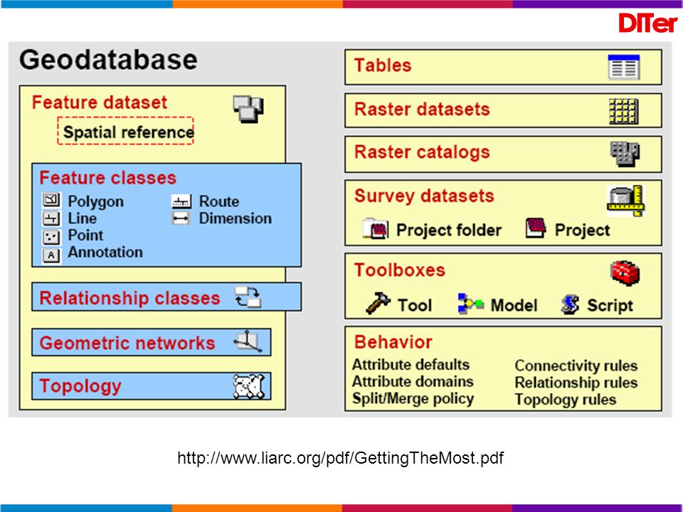
Il software GIS. I dati e le relazioni

23
Relazioni spaziali La caratteristica chiave dei G.I.S. è la capacità di integrazione, cioè di relazionare dati attraverso il riferimento spaziale. Si tratta di sovrapporre (overlay) strati informativi diversi. Huxold (1991, pp. 320, 327) propone una distinzione tra: integrazione orizzontale (dati diversi vengono messi in relazione in quanto riferiti alla stessa entità geografica, ad esempio allo stesso isolato); integrazione verticale (vengono aggregati i dati riferiti ad entità geografiche che appartengono ad una entità geografica di livello superiore, ad esempio dati riferiti all'isolato vengono aggregati per quartiere). Nel primo caso le entità geografiche appartengono ad un unica classe, nel secondo si analizza il rapporto di inclusione tra due classi di entità geografiche.
 strati informativi diversi. Huxold (1991, pp. 320, 327) propone una distinzione tra: integrazione orizzontale (dati diversi vengono messi in relazione in quanto riferiti alla stessa entità geografica, ad esempio allo stesso isolato); integrazione verticale (vengono aggregati i dati riferiti ad entità geografiche che appartengono ad una entità geografica di livello superiore, ad esempio dati riferiti all isolato vengono aggregati per quartiere). Nel primo caso le entità geografiche appartengono ad un unica classe, nel secondo si analizza il rapporto di inclusione tra due classi di entità geografiche.")
25
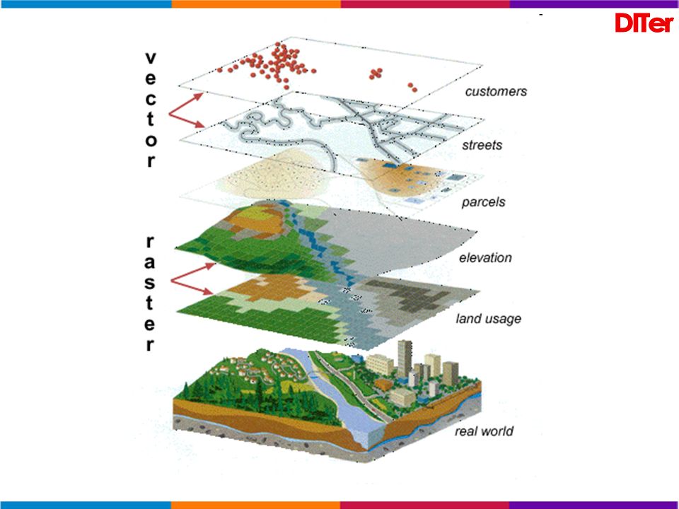
Dati raster e vettoriali
Il dati raster o meglio le immagini raster sono fatte da una serie di celle a griglia (bitmap) e possono essere acquisite tramite scanner o semplicemente possono essere una fotografia (aerea, satellitare…). I dati vettoriali sono costituiti sostanzialmente da punti, linee, e poligoni e vengono memorizzati con l’informazione che riguarda il loro riferimento geografico (x, y).
 e possono essere acquisite tramite scanner o semplicemente possono essere una fotografia (aerea, satellitare…). I dati vettoriali sono costituiti sostanzialmente da punti, linee, e poligoni e vengono memorizzati con l’informazione che riguarda il loro riferimento geografico (x, y).")
26
Layers Vector Layers Street Network layer: lines
Land Parcels layer: polygons Raster (image) Layer Digital Ortho Photograph Layer: Digital Ortho photo: combines the visual properties of a photograph with the positional accuracy of a map, in computer readable form. 1500 3000 Feet
 Layer. Digital Ortho Photograph Layer: Digital Ortho photo: combines the visual properties of a photograph with the positional accuracy of a map, in computer readable form Feet.")
27
La Georeferenziazione e’ il processo attraverso il quale un oggetto viene posizionato su una carta secondo un sistema di coordinate

28
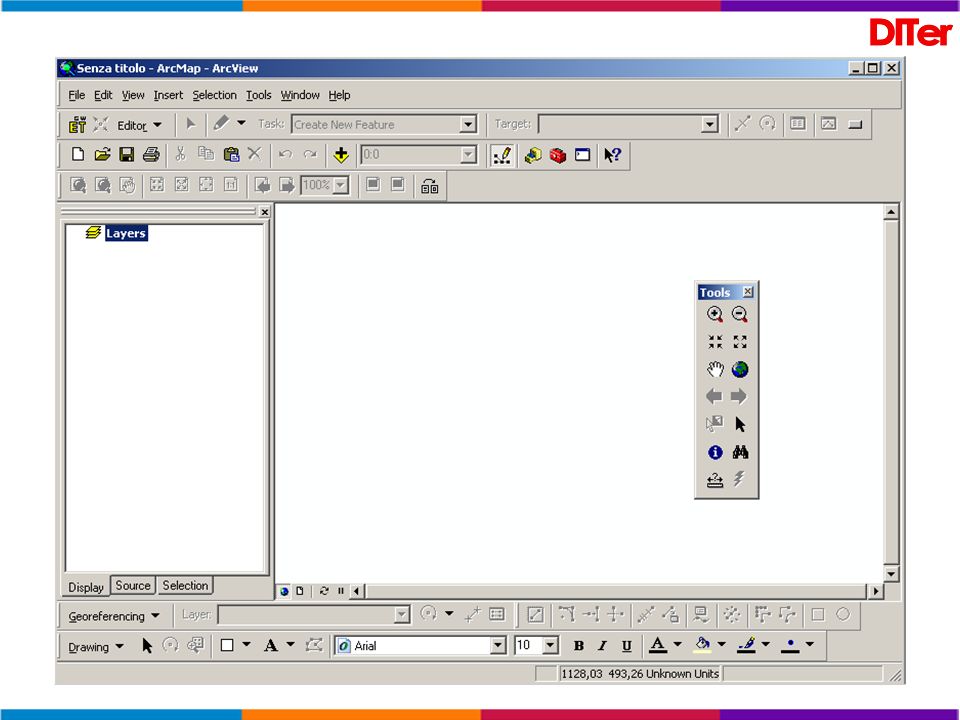
Georeferenziazione “al volo” con ArcGIS
CTR con individuazione dei Punti di Controllo Immagine da georiferire con individuazione dei Punti di Controllo

29
Immagine georiferita

30
In un GIS, ogni feature “contiene” dati o è relazionata a “fonti” esterne

31
Operazioni sui dati: GEOprocessing in ArcView 3.x

32
Operazioni sui dati: GEOprocessing in ArcGIS
Data extraction creating a subset of features from one data set based on the geographic extent of another Overlays combination of two or more data sets to create new data set Proximity finding areas that are near features

33
Overlay Le operazioni di overlay portano ad analizzare le relazioni topologiche (relazioni tra diversi elementi spaziali) esistenti fra entità geografiche: di prossimità e adiacenza; di inclusione, un oggetto contiene completamente, o è contenuto completamente da un altro; di connessione, per le reti; di intersezione. L'analisi delle intersezioni può portare alla generazione di nuove entità geografiche.
 esistenti fra entità geografiche: di prossimità e adiacenza; di inclusione, un oggetto contiene completamente, o è contenuto completamente da un altro; di connessione, per le reti; di intersezione. L analisi delle intersezioni può portare alla generazione di nuove entità geografiche.")
34
Selezione in base alla localizzazione…

35
Operazioni sui dati: selezione di features per mezzo dei loro attributi (dati associati)
ArcGis 9.x ArcView 3.x

36
Relazioni topologiche
Topology is defined as the “spatial relationships between adjacent or neighboring features.”

37
Strumenti per verificare le “regole” geometriche

38
Relazioni alfanumeriche

39
Il software ArcGIS e la sua interfaccia

41
Tutte (o quasi) le barre degli strumenti (nascoste)…
Con il tasto destro del mouse su un’area “vuota” della menu bar è possibile richiamare l’elenco delle barre degli strumenti…

42
Edit Toolbar

43
ArcGIS 9.3 è un software GIS deputato alla visualizzazione, interrogazione, creazione di dati e mappe GIS da utilizzarsi in ambiente Windows desktop. ArcGIS 9.3 è costituito da 3 applicazioni: ArcMap (map-making and analysis) ArcCatalog (accessing and managing data) ArcToolbox(an environment for performing data processing operations such as geodata conversion)
 ArcCatalog (accessing and managing data) ArcToolbox(an environment for performing data processing operations such as geodata conversion)")
44
ArcMap ArcMap rappresenta l’evoluzione di Arcview. Permette di realizzare una mappa partendo la Layer predefiniti oppure caricando temi vettoriali, immagini, eccetera. Altre due applicazioni, ArcCatalog e ArcToolbox, consentono di navigare, organizzare e documentare i dati (ArcCatalog) ed effettuare operazioni di GeoProcessing utilizzando l’insieme degli strumenti contenuti in ArcToolbox
 ed effettuare operazioni di GeoProcessing utilizzando l’insieme degli strumenti contenuti in ArcToolbox.")
45
ArcCatalog… il visualizzatore “universale”
ArcCatalog permette di: Visualizzare layers, mappe, shapefiles, tabelle di dati (Ms-Access...); Creare e Visualizzare dati e metadati; Utilizzare dati in ArcMap e ArcToolbox; Gestire i dati (copiare, rinominare, cancellare…) utilizzando uno strumento stile “gestione risorse”…
; Creare e Visualizzare dati e metadati; Utilizzare dati in ArcMap e ArcToolbox; Gestire i dati (copiare, rinominare, cancellare…) utilizzando uno strumento stile gestione risorse …")
46
ArcCatalog… Gestione delle risorse

47
ArcToolbox è organizzato in set di tools.
I principali “Toolsets” sono raggruppati “per famiglie”: Data Management Tools Analysis Tools Conversion Tools My Tools [ambienti di sviluppo possibili: Visual Basic 6.0 , Visual C++, Delphi, Sybase PowerBuilder, ... ] Nel caso non si riuscisse a trovare la risorsa di interesse, è sempre possibile consultare l’elenco alfabetico dei “tools” oppure utilizzare un apposito “motore di ricerca”

48
ArcToolBox: la “cassetta degli attrezzi”
Definizione guidata di proiezioni geografiche (“wizards”) Creare strumenti personalizzati nell’ambiente di sviluppo desiderato (compatibile con Microsoft Windows) ed installarli come Tools aggiuntivi in ArcToolbox. Import dati da Coverage a personal geodatabase da Shapefile a personal geodatabase da Raster a MrSID… Export dati da dati vettoriali (vector layer) a personal geodatabase da Shapefile a DXF da raster layer a TIFF, IMG, o Grid…
 Creare strumenti personalizzati nell’ambiente di sviluppo desiderato (compatibile con Microsoft Windows) ed installarli come Tools aggiuntivi in ArcToolbox. Import dati. da Coverage a personal geodatabase. da Shapefile a personal geodatabase. da Raster a MrSID… Export dati. da dati vettoriali (vector layer) a personal geodatabase. da Shapefile a DXF. da raster layer a TIFF, IMG, o Grid…")
49
ArcToolbox di ArcInfo Oltre 150 Tools...

50
Da ArcView 3.x ……………….. a ArcView 9.x
ArcView GIS 3.x Project………………………………… Theme………………………………… View, View frame……………………. Projection…………………………….. Avenue scripts ……………………….. Active Theme ………………………… AVL (legend file) ……………………. DDE………………………………….. Promote Selected…………………….. Database theme………………………. CAD Reader………………………….. Grid, Image theme……………………. Extensions……………………………. Add/Remove field……………………. New shapefile………………………… Summarize……………………………. SQL Connect…………………………. … ArcView 9.x Map document Layer Data frame Coordinate system VBA macros Selectable layers Import symbology from layer file OLE Open Table for Selected Geodatabase layer CAD layer Raster layer Extensions and toolbars ArcCatalog or ArcMap ArcCatalog Dissolve Wizard Add OLE DB Connection (ArcCatalog) …
 ……………………. DDE………………………………….. Promote Selected…………………….. Database theme………………………. CAD Reader………………………….. Grid, Image theme……………………. Extensions……………………………. Add/Remove field……………………. New shapefile………………………… Summarize……………………………. SQL Connect…………………………. … ArcView 9.x. Map document. Layer. Data frame. Coordinate system. VBA macros. Selectable layers. Import symbology from layer file. OLE. Open Table for Selected. Geodatabase layer. CAD layer. Raster layer. Extensions and toolbars. ArcCatalog or ArcMap. ArcCatalog. Dissolve Wizard. Add OLE DB Connection (ArcCatalog) …")
51
ArcView 3.x …

52
ArcView 9.x … Title bar Menu Bar Standard Toolbar Data frame
Map display Toolbar Layers Selection Source Table of contents ArcView 9.x … Draw bar Status bar

53
Context menu

54
Layers Le Informazioni Geografiche sono visualizzate sulla mappa come “Layers”. Ciascun Layer rappresenta un particolare tipo di features (fiumi, laghi, limiti amministrativi…). Un Layer non memorizza i dati geografici ma si collega ai dati contenuti in coverages, shapefiles, geodatabases, images, grids eccetera.
. Un Layer non memorizza i dati geografici ma si collega ai dati contenuti in coverages, shapefiles, geodatabases, images, grids eccetera.")
55
I layers contengono anche le informazioni relative alle “legende”, alla visibilità del tema rispetto alla scala di lavoro, alle “definition queries”, ai join ed ai link.... Ad ogni aggiornamento del dato vengono aggiornati automaticamente anche i layers ad esso collegati.

56
Tools interattivi per “esplorare” e selezionare dati…
Map tips (basati sulla “primary label name”) Magnification window Overview window Spatial bookmarks
 Magnification window. Overview window. Spatial bookmarks.")
57
Magnification window

58
Spatial bookmarks

59
Pubblicazione e stampa di una mappa

60
Extensions for ArcInfo, ArcEditor, and ArcView
Using optional extensions with ArcGIS desktop products allows you to perform extended tasks such as raster geoprocessing and three-dimensional analysis. Unless noted, extensions can be used with ArcInfo, ArcEditor, and ArcView. Zone visibili dalla torre antincendio “A” posta in alto a sinistra Rappresentazione del centro di Seattle

61
ARCGIS Extensions Analysis ArcGIS 3D Analyst (includes ArcGlobe)
ArcGIS Geostatistical Analyst ArcGIS Network Analyst ArcGIS Schematics ArcGIS Spatial Analyst ArcGIS Survey Analyst ArcGIS Tracking Analyst Verifica del livello dell’inquinamento acustico nei pressi dell’aeroporto Productivity ArcGIS Data Interoperability ArcGIS Publisher ArcGIS StreetMap (included with ArcGIS 9.1 and higher) ArcPress for ArcGIS (included with ArcGIS 9.1 and higher) ArcScan for ArcGIS (included with ArcInfo and ArcEditor 9.1 and higher) Maplex for ArcGIS (included with ArcInfo 9.1 and higher)
 ArcPress for ArcGIS (included with ArcGIS 9.1 and higher) ArcScan for ArcGIS (included with ArcInfo and ArcEditor 9.1 and higher) Maplex for ArcGIS (included with ArcInfo 9.1 and higher)")
62
ARCGIS Extensions Solution-based ArcGIS Defense Solutions
* ArcGIS Military Analyst (download) * Grid Manager (download) * MOLE (download) Job Tracking for ArcGIS (JTX) (requires ArcEditor or ArcInfo) Production Line Tool Set (PLTS) for ArcGIS (requires ArcEditor or ArcInfo) No Cost Add-Ons ArcSketch (download) Census Tools for ArcGIS (download) Districting for ArcGIS (download) Geodatabase Toolset (GDBT) (download) GIS Portal Extensions for ArcGIS (download) OLAP for ArcGIS (download) U.S. National Grid Tools for ArcGIS (download)
 * Grid Manager (download) * MOLE (download) Job Tracking for ArcGIS (JTX) (requires ArcEditor or ArcInfo) Production Line Tool Set (PLTS) for ArcGIS (requires ArcEditor or ArcInfo) No Cost Add-Ons. ArcSketch (download) Census Tools for ArcGIS (download) Districting for ArcGIS (download) Geodatabase Toolset (GDBT) (download) GIS Portal Extensions for ArcGIS (download) OLAP for ArcGIS (download) U.S. National Grid Tools for ArcGIS (download)")
63
ArcGIS Tablet PC

64
Tablet PC for ArcGIS ESRI has developed a set of tools to support Tablet PC for ArcGIS, built to the design specifications of Microsoft Windows XP Tablet PC Edition. These tools allow ArcGIS users to take advantage of the Tablet PC's innovative features such as pen-based computing, digital ink technology, and enhanced mobility functions.

65
Tutti gli schizzi e le note, create con ArcGIS su un Tablet PC, sono “geograficamente referenziate” e possono essere salvate come “graficismi” sulla mappa oppure come annotazioni in un geodatabase.

66
Strumenti & Tools

67
INFORMAZIONI TECNICHE E STRUMENTI
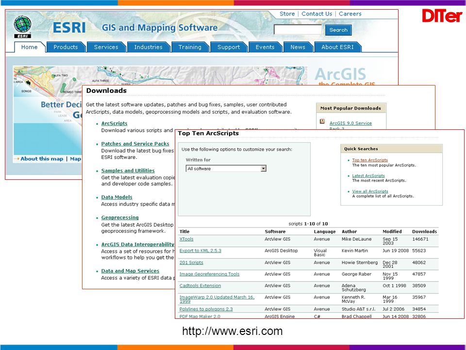
Il modo piu semplice per “trovare” documenti, strumenti (“tools”) o dati georiferiti è quello di scaricarli dal WEB. Se non si conosce la URL sorgente è possibile cercare le informazioni di interesse utilizzando un semplice motore di ricerca. Così, ad esempio, immettendo nel dialogo le seguenti stringhe: shapefile, raster, vettoriale, gis, sit, sistema informativo territoriale si ottiene un qualcosa del genere…
 o dati georiferiti è quello di scaricarli dal WEB. Se non si conosce la URL sorgente è possibile cercare le informazioni di interesse utilizzando un semplice motore di ricerca. Così, ad esempio, immettendo nel dialogo le seguenti stringhe: shapefile, raster, vettoriale, gis, sit, sistema informativo territoriale si ottiene un qualcosa del genere…")
70
http://www. regione. piemonte
72
Fine della Parte Seconda

Presentazioni simili

 064825120 - fax.>")


 & SQL Server 2005 Express.>")


 abbiamo cominciato a lavorare utilizzando i maniera didattica tecnologie di tipo hardware.>")

 relazionale client/server.>")

