Scaricare la presentazione
La presentazione è in caricamento. Aspetta per favore

1
DSM in Italy: the case study of the PRIN project Terribile F (1)., Aru A., Basile A (3)., Bocchi S. (4), Bonfante A. (1), Bonifacio E. (5), Buttafuoco G. (3), Cantelli D. (6), Carnicelli S. (7), Castrignanò A. (8), Ciampalini R. (7), Comolli R. (6), Dazzi C. (9), De Mascellis R. (3), Falsone G. (5), Iamarino M. (1), Iasio C. (7), Laudicina V. A. (9), Lo Papa G. (9), Lopez R. (4), Manna P. (1), Monteleone S. (7), Parello F., Parisi S., Paternò M., Provenzano G., Scalenghe R. (9), Territo C. (9), Tusa D. (9), Vacca A. (2), Vingiani, S (1)., Wolf U. (7), Zanini E., Zucca C (6). (1) DISSPA Università di Napoli Federico II; (2) Università di Cagliari; (3) CNR ISAFOM, Ercolano; (4) Università di Milano; (5) Università di Torino; (6) Università di Milano Bicocca; (7) Università di Firenze; (8) ISA MIPAF Bari; (9) Università di Palermo
, Bonfante A. (1), Bonifacio E. (5), Buttafuoco G. (3), Cantelli D. (6), Carnicelli S. (7), Castrignanò A. (8), Ciampalini R. (7), Comolli R. (6), Dazzi C. (9), De Mascellis R. (3), Falsone G. (5), Iamarino M. (1), Iasio C. (7), Laudicina V. A. (9), Lo Papa G. (9), Lopez R. (4), Manna P. (1), Monteleone S. (7), Parello F., Parisi S., Paternò M., Provenzano G., Scalenghe R. (9), Territo C. (9), Tusa D. (9), Vacca A. (2), Vingiani, S (1)., Wolf U. (7), Zanini E., Zucca C (6). (1) DISSPA Università di Napoli Federico II; (2) Università di Cagliari; (3) CNR ISAFOM, Ercolano; (4) Università di Milano; (5) Università di Torino; (6) Università di Milano Bicocca; (7) Università di Firenze; (8) ISA MIPAF Bari; (9) Università di Palermo.")
2
It is a national project funded by the Italian Ministry of Research (PRIN) It is a project on methodologies to address spatial variability issue for soil mapping
 It is a project on methodologies to address spatial variability issue for soil mapping")
3
An introduction to the approach In the last decade, in Italy soil mapping has indeed become a strategic tool for landscape planning at different levels (village, district, region, country) and for different purposes The methodologies have been well standardised and, of course, they all rely on georeferenced databases. Soil survey is generally performed on the budget of the different administrative regions and it is generally made by private companies of pedologists.

4
The standard approach – deterministic and discontinuous (s=f(cl,o,r,p,t…))
)")
7
Despite the extremelly high value of the results obtained by soil mapping……………there are some problems ……….

8
Of course the problem of spatial variability inside each soil mapping and soil type units it is an old problem Nelson e McCracken, 1962; Andrew e Stearns, 1963; Mader, 1963; Wilding et al., 1964; Powel e Springer 1965; Beckett e Webster, 1971; Bascomb e Jarvis 1976; Wilding et al. 1965; McCormack e Wilding; Nettleton et al. (1991).
..")
9
But also the lack of some major physical and hydrological soil properties (i.e. hydraulic conductivity; water retention curve, mechanical resistivity, etc.…) This make difficult for soil map to properly address many functional soil properties (i.e. related to water movement) Information on the spatial variability of the soil physical properties are becoming a must in environmental studies,….. if meaningful result have to be given. Such framework is extremelly important moving towards the use of physically based models. Such limitation is one of the major problems in future application of soil mapping to address many environmental and agricultural problems.
 This make difficult for soil map to properly address many functional soil properties (i.e. related to water movement) Information on the spatial variability of the soil physical properties are becoming a must in environmental studies,….. if meaningful result have to be given. Such framework is extremelly important moving towards the use of physically based models. Such limitation is one of the major problems in future application of soil mapping to address many environmental and agricultural problems..")
10
Some of our problems ….

11
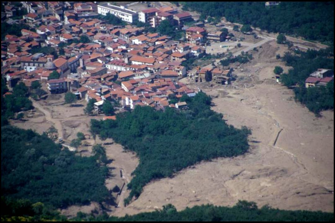
Volcanic soils and triggering mechanisms of landslide initiation: the case study of Sarno e Quindici (ad es. Basile, Mele, Terribile. 2002. Soil hydraulic behaviour of a selected benchmark soil involved in the landslide of Sarno 1998. Geoderma Elsevier)
.")
13
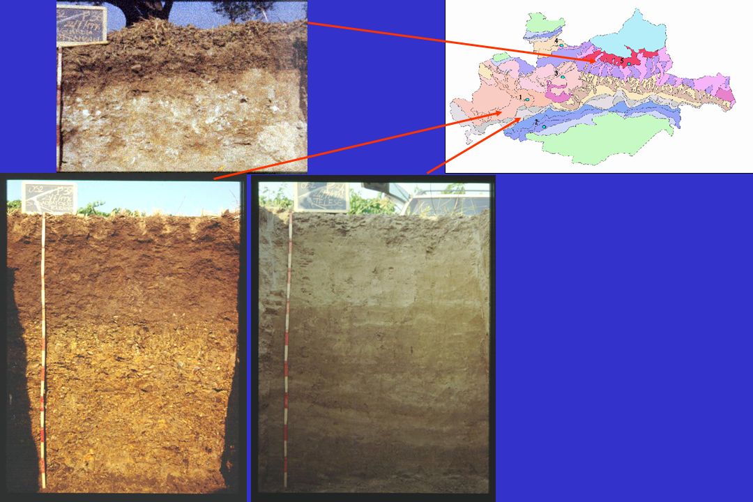
Campi Flegrei Monti Lattari

14
Monti Lattari:Typic Hapludand Campi Flegrei (Gauro): Ustivitrand
: Ustivitrand")
15
Tipologia di modelli utilizzati An example of the influence of soil type on pollution susceptibility of shallow groundwater Basile, A., De Mascellis, R., Terribile, F. 1999. Il suolo e la protezione degli acquiferi: studio pedologico e idrologico dei suoli della piana del F. Sarno (Campania). Quaderni di Geologia Applicata. Numero monografico su "Rischio di Inquinamento"; pubbl. GNUCI- CNR n. 2000. pp. 1251-1261
. Quaderni di Geologia Applicata. Numero monografico su Rischio di Inquinamento ; pubbl. GNUCI- CNR n pp")
17
All these soils are sandy loam; they have the same score of the soil parameters in the (widespread) empirical models like DRASTIC/SINTACS
 empirical models like DRASTIC/SINTACS")
18
Parametri idrodinamici del trasporto nei suoli franco sabbiosi unitàRP D (cm 2 min -1 ) V (cm min -1 ) Pal4 1.13 1.06 7.79 1.03 Pal5 1.31 0.47 1.06 0.05 Pal6 0.80 8.52 0.13 0.11 Pal8 0.92 1.74 1.36 0.28 Pal10 0.73 2.3 3.42 0.6 Vas1 0.89 7.29 1.11 0.61 Vac2 0.91 2.71 7.30 1.86
 V (cm min -1 ) Pal Pal Pal Pal Pal Vas Vac")
19
S1 S 12

20
S1 S 12

22
U 10 U 6 13 10 11 18 15 8 6-32 7 6 3 2 1 4 5 9 7 8 1 6 S N 2 10-21 5 5 4 3 13-31 2 1 11-28 9 8 10 1 13 14 6 3 2 11-30 4 5 11 12 T R 0123Kilometers N Aquic Xerofluvent

24
The general aims of the project : To approach the difficult problem of soil variability in soil mapping analysing the soil continuum by: Standard soil survey Geostatistical approaches Deterministic continuum approaches (i.e.DEM derived parameters; vegetation indexes, etc.) using covariates
 using covariates")
25
Measurements with a high benefit/cost ratio for high resolution survey (i.e. vegetation spectral indexes, geophysics, ultrasonic penetrometry, field fluorescence spectrometry, etc.) Measurement of highly relevant physical properties for low resolution survey (i.e. automatic tension infiltrometers, REV, etc.)
 Measurement of highly relevant physical properties for low resolution survey (i.e. automatic tension infiltrometers, REV, etc.).")
26
The research proposal has involved the following univerisites: Napoli, Firenze, Torino, Milano, Cagliari, Palermo and 2 research institute (CNR Isafom of Napoli and ISA of Bari). Years: 2002- 2006

27
The people in charge of the project : Coordinator: F. Terribile Pedology: R. Comolli; C. Dazzi Soil hydrology: A. Basile Geostatistics: A. Castrignanò Continuous deterministic approaches – S. Carnicelli Geophysics: Geostudi (private company) & A. Vacca Aggregation: Eleonora Bonifacio
 & A. Vacca Aggregation: Eleonora Bonifacio.")
28
Valchiavenna (300 ha) Lodigiano (2000 ha) Mustigarufi (150 ha) Study sites: training sites for the group
 Lodigiano (2000 ha) Mustigarufi (150 ha) Study sites: training sites for the group")
29
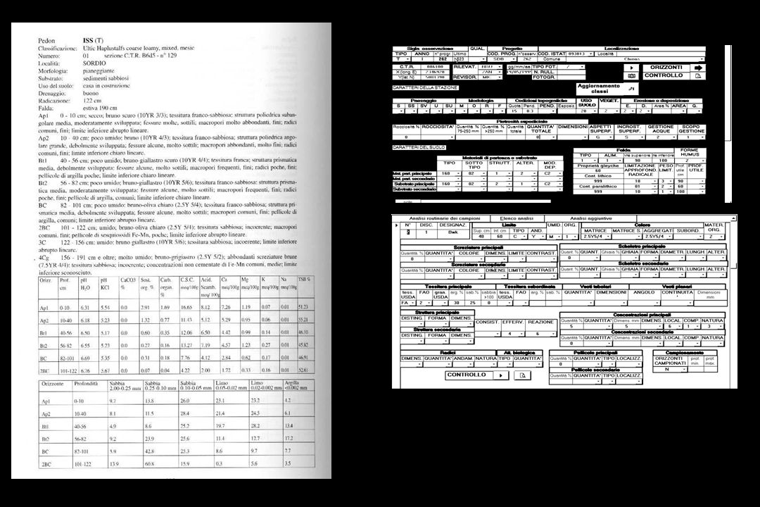
Main analysis for each study area Field 100 + 80 (in a sub-area) profile/auger/minipit description 100 + 80 (in a sub-area) penetrometric measurements About 30 infiltrometry test (70% with TDR measurements); Undisturbed samples for hydrology micromorphology on benchmark soils (about 5 profiles); Geophysical continuous measurement (mainly EM) lab Water retention curve, Ks and micromorphology on benchmark soils PSD, pH (water, KCl), total geochemistry, C org, N, carbonates, etc. on all the soils Aggregate stability

32
Foto A Linea 1 Linea 2 FIG 8

33
C 10000 Hz Linea 1 Picchetto 1 Picchetto 24 Picchetto 24= 0402 Linea 2 Sondaggio foto A CONFRONTO GEM 300 – RESISTIVITA FIG 7 Picchetto 1= 0404

34
Sondaggio 0404 Sondaggio 0402 FIG. 9

35
EM38DD

36
Area 1 traccia DGPS

37
Area 1 bobine verticali profondità 1.5m circa misure conducibilità mS/m Prato: Area non coltivata Porzione iniziale dove lo strumento non è stato calibrato in maniera corretta

38
Spatial distribution

39
Limite inferiore del primo orizzonte superficiale Sabbia Carbonio Organico N totale Valchiavenna

40
N totale DISTANZE (m) LAG S E MI V A RI A N Z E Υ Carbonio
 LAG S E MI V A RI A N Z E Υ Carbonio")
41
Co-Kriging collocato dellN back- trasformato e della quota nel I° orizzonte superficiale

42
Landforms classification (Unsupervised Fuzzy k-means) elevation slope flow accumulation soil types and landforms (Unsupervised Fuzzy k-means classification) Soil data: Minipits: n. 110 Profiles: n. 5 CASE STUDY: Valchiavenna (Central Alps – Italy)** Landform classes Lanscape analysis and soil variability
** Landform classes Lanscape analysis and soil variability.")
43
slope tangential curvatureprofile curvature flow accumulation Landforms classification (Supervised Fuzzy k-means) Soil types: average terrain data (slope, tangential curvature, profile curvature, flow accumulation) (Supervised Fuzzy k-means classification)
 Soil types: average terrain data (slope, tangential curvature, profile curvature, flow accumulation) (Supervised Fuzzy k-means classification)")
44
67 11 21 37 8 42 35 15 Percentage of soil type data accounted by their terrain average values Podzols mapCambisols mapLeptosols map Soil type data: Podzol: n. 42 Cambisol: n. 24 Leptosol: n. 20

45
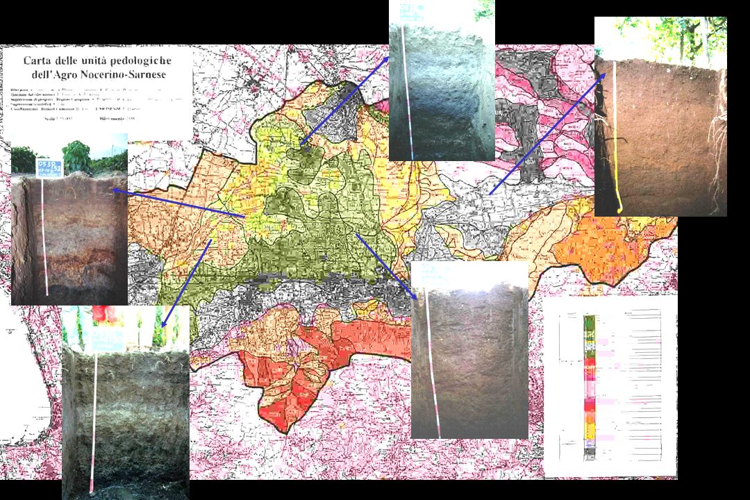
First Conclusions We produced, in the 3 study areas, a unique soil database (at least for Italy), in terms of type of analysis and spatial resolution of the measurements. It is a very important site where to test methodologies on spatial variability Feasibility of producing in little time (1-2 weeks /area) an intensive survey of morphological and physical measurements.
 an intensive survey of morphological and physical measurements..")
46
First Conclusions We now plan to address the soil functioning especially in the plain of Lodi with reference to two applications: (i) filtering (nitrate leaching); (ii) crop production The project will finish in dec 2005 and …..we are very much looking for collaborations and help……
 filtering (nitrate leaching); (ii) crop production The project will finish in dec 2005 and …..we are very much looking for collaborations and help……")
47
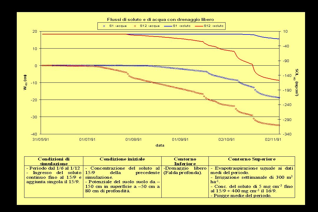
Modello di simulazione (SWAP) OUTPUT proprietà funzionali W -80 e SOL -80 PARAMETRI SPAZIALMENTE DIPENDENTI Proprietà idrauliche Parametri di trasporto dei soluti PARAMETRI SPAZIALMENTE INDIPENDENTI Parametri della coltura (Kc, funzione di attingimento radicale, etc) Condizioni Iniziali e al contorno inferiore (falda) e superiore (ETp, pioggie, irrigazioni, sversamenti, etc)
 OUTPUT proprietà funzionali W -80 e SOL -80 PARAMETRI SPAZIALMENTE DIPENDENTI Proprietà idrauliche Parametri di trasporto dei soluti PARAMETRI SPAZIALMENTE INDIPENDENTI Parametri della coltura (Kc, funzione di attingimento radicale, etc) Condizioni Iniziali e al contorno inferiore (falda) e superiore (ETp, pioggie, irrigazioni, sversamenti, etc)")
48
Richards C(h) h/ t = / z [ K(h) ( h/ z + 1)] - S EQUAZIONI DEL MOTO DELLACQUA E DEL TRASPORTO DEI SOLUTI Convezione-Dispersione R ( C r / T) = 1/ P ( 2 /C r / Z 2 ) - ( C r / Z)
![Richards C(h) h/ t = / z [ K(h) ( h/ z + 1)] - S EQUAZIONI DEL MOTO DELLACQUA E DEL TRASPORTO DEI SOLUTI Convezione-Dispersione R ( C r / T) = 1/ P ( 2 /C r / Z 2 ) - ( C r / Z)](http://images.slideplayer.it/1/552027/slides/slide_48.jpg "Richards C(h) h/ t = / z [ K(h) ( h/ z + 1)] - S EQUAZIONI DEL MOTO DELLACQUA E DEL TRASPORTO DEI SOLUTI Convezione-Dispersione R ( C r / T) = 1/ P ( 2 /C r / Z 2 ) - ( C r / Z)")
Presentazioni simili


 Brussels, 26 settembre 2013.>")
 064825120 - fax.>")
 1-5 December, 2003 Paolo Berardino, Michele Manunta, Massimo Marrazzo,>")


>")


