Scaricare la presentazione
La presentazione è in caricamento. Aspetta per favore

1
THE GEOGRAPHY OF LAKE BOLSENA
A CLIL Project By Class IV° B Primary School “Anna Molinaro” in Montefiascone(VT)
")
2
Descrizione del progetto.
Destinatari: i 22 alunni della classe IV° B della scuola Primaria «O. Golfarelli», Montefiascone (VT). Tempi e modalità: 10 lezioni di un’ora ciascuna con cadenza settimanale. Materie coinvolte: geografia, inglese Finalità: 1. Arricchire il piano linguistico, cognitivo e relazionale. 2. Usare la lingua inglese in modo autentico cioè cognitivamente più profondo. 3. Approfondire la conoscenza del territorio partendo dalla valorizzazione di quello di appartenenza. 4. Migliorare l’offerta formativa della scuola aprendola ad una dimensione europea.
. Tempi e modalità: 10 lezioni di un’ora ciascuna con cadenza settimanale. Materie coinvolte: geografia, inglese. Finalità: 1. Arricchire il piano linguistico, cognitivo e relazionale. 2. Usare la lingua inglese in modo autentico cioè cognitivamente più profondo. 3. Approfondire la conoscenza del territorio partendo dalla valorizzazione di quello di appartenenza. 4. Migliorare l’offerta formativa della scuola aprendola ad una dimensione europea.")
3
Descrizione del progetto.
Metodologia: 1. deduzione e ripetizione parole chiave riferite alla geografia del lago di Bolsena 2. richiesta di conferma della comprensione 3. ricorso ad esempi concreti 4. spiegazione di significati 5. sintesi dei contenuti affrontati Valutazione: Uso di giochi interattivi sul sito come accoppiamento di parole alle immagini e cruciverba, ecc….( – )
")
4
the LARGEST VOLCANIC lake in Europe.
Lake Bolsena the LARGEST VOLCANIC lake in Europe.

5
Volcanic origins: 7 volcanoes exploded, blew up, and collapsed forming a great depression called “caldera” (catchment area). We analyze the internal structure of a volcano.

6
The surface area of lake Bolsena is 113,5 squarekilometers
The surface area of lake Bolsena is 113,5 squarekilometers. It is 305 meters above the sea level. Its maximum depth is 151 meters. Its medium depth is 81 meters.

7
Lake Bolsena has got an OVAL shape
Lake Bolsena has got an OVAL shape. Martana Island and Bisentina Island enrich its charm. The islands are the remains of the volcanoes. Martana Island Bisentina Island

8
Studying the cardinal points on Martana Island.

9
Studying the cardinal points on Martana Island.

10
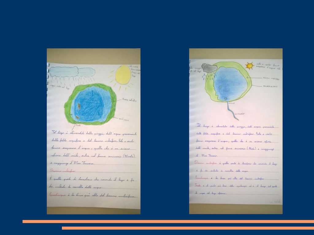
The rain, the water coming from the groundwater table and from the catchment area feed the lake.

12
The catchment area is the part of land surrounding the lake and becomes a funnel that collects waters.

13
Watershed is the highest line of the catchment area.

14
The sun and the wind let the water dry and the water in excess skims from the drain, enters the emissary river (river Marta) and reaches the Tyrrhenian sea. Drain: river Marta

15
This is a game that all students made on learningapps
This is a game that all students made on learningapps.org

Presentazioni simili

, and.>")


 1. Ogni bambino ha diritto all’istruzione senza distinzioni razziali. 1. Every child has the right to be brought up without.>")
